The length includes the passage beyond the duck to sump 2, but not the lengths of the sumps.
In the mid-July 2014 "lots of water" was seen to flow down the Arroyo de Canastrillas, to the west of Solórzano. At that time, there was too much jungle to reach the resurgence.
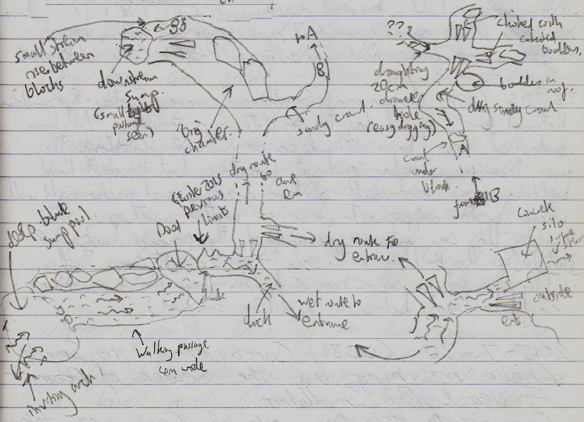
The cave was explored and partly surveyed at Easter 2015. A high level passage goes for about 100m to a diveable sump that has water flowing into it. The water can be followed upstream from the entrance for about 40m through a couple of ducks to where it intersects the high level.
A draughting, sandy dig at the end of the dry cave was excavated at the end of July 2015. A calcited chamber was entered with a smaller sandy tube continuing. There is a good draught and digging is easy. The upstream sump was also free-dived into about 20m of 4m wide, walking passage ending at a large, blue sump. A large arch can be seen below and the site is seen as an excellent diving prospect.
This sump was dived by Jim Lister in April 2016. A steeply descending passage reaches 3.2m depth before meeting a boulder blockage with possible passage seen beyond. "This sump would be worth digging if there weren't so many open sumps elsewhere. A tirfor and lots of trips would be needed to do this."
The northern sump was dived by Colin Hayward in August, 2016. A depth of 2.8m was reached via a tube in roof over a silt floor. A roof flake is met with routes off each side, probably staying at -2.8m where the silt closes up to tghe roof in two mini chambers. Three dives were made on the day, the second and third without fins. On the third, a boulder was taken into the sump to provide a belay at the flake.
This sump takes water from a rising in the cave off to one side of the sump pool. It most likely backs up in wet weather and may only drain slowly. The depth of the sump may only be accurate on the day and the boulder taken in to belay the line may move further down the slope in the silt floor. The line was removed after the dive. [Northern sump account by Colin Hayward]
The survey was corrected with the sumps placed in the correct positions in August 2016.
In early February 2018, over a period with some heavy rain, optical brightener was injected into site 4658, near Garzón. The OBA was not detected here but was detected at site 3282, Santa Juliana. More details and a map can be seen on the hydrology page.
"There is enough large passage in this cave to make the rest of the surrounding area well worth further scampering"
See also site 4407.
Link to entry in the Cave Diving Sump Index.
Reference: anon., 2014c (summer logbook); anon., 2015b (Easter logbook); anon., 2015c (summer logbook); anon., 2016b (Easter logbook); anon., 2016c (summer logbook); anon., 2018a (January, February logbook)
Entrance pictures : yes
Underground pictures : northern sump, August 2016
Video : Digging and free-diving activities, 29th July 2015 (YouTube) : diving the northern sump (YouTube)
Detailed survey : 1:500 pdf : sketch July 2015 explorations : 1:500 pdf updated 2015
Sketch of terminal upstream sump 2, Easter 2016: 1:500 pdf updated Easter 2016 : corrected survey, August 2016 : sketches of northern sump
Line Survey :
On area survey :
Survex file : with Easter 2016 approx. data to sump 2