Updated 18th January 2011
This site is described on the web site of the Sociedad Espeleológica
Alto Duero who have explored it. It would appear that the entrance has been
located with GPS but the altitude (in brackets above) is wrong when plotted
on 1:5000 maps.
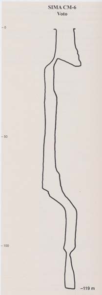
A 9m long rift is a pitch of 17m. A ramp descends to a choke but at the top
is the head of a 55m pitch. At the base, 2 small, 1m diameter tubes lead
onto the continuation and another pitch of nearly 59m. This appears to add
up to 130m and not the indicated 119m.
Reference: SEAD website; file; León García José, 2010 (Volume 1 and Volume 2) (survey and photos)
Entrance picture: on the SEAD website
Underground picture(s):
Detailed survey: elevation on the SEAD website : elevation from León García José, 2010 (Volume 1 and Volume 2). (Cantabria Subterránea. Catálogo Grandes Cavidades.)
Line survey:
On area survey:
Survex file: