Updated 11th February 2016; 24th September 2018; 15th November 2022
The information has been roughly translated from the French, Simonnot G, 2018. The grid reference
and altitude are taken from the MCP map.
Fifty meters from the road from Santander to Arredondo (km 23.5), at the edge of the road that goes up to Garmalloso and Colorado.
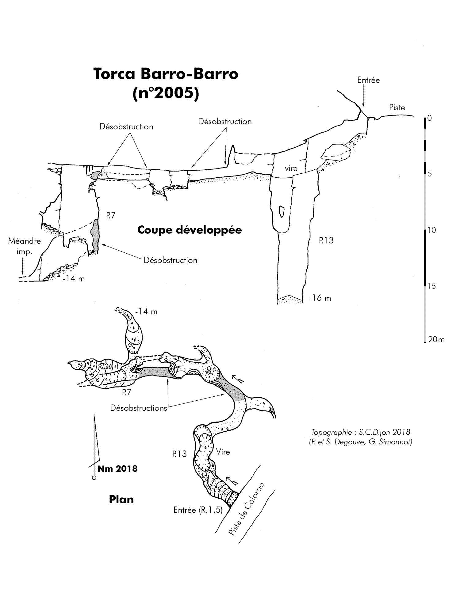
The unobstructed entrance gives access at -3m to the top of a 13 m blocked pitch. A crossing above the pitch makes it possible to reach a start of meander which is quickly impenetrable.
It should be noted that there is a clear draft current at the entrance during the summer period. In winter the sense is reversed and the cavity blows strongly. In 2018, a hard day of disobstruction allows the crossing of the beginning of the meander and access to a route on a few metres finding a new passage to enlarge.
This meander has been opened up to a p10 with a rift at the base that becomes too tight.
(The grid reference in
Simonnot G, 2016 and Simonnot G, 2018 puts the entrance below the main road).
The information for this site (below) has been updated in Simonnot G, 2022 and roughly translated from the French using Google Translate as a starting point.
A crossing above the 13m pitch reachs a meander which has been emptied of its clay filling over 5 m. Behind a comfortable route, which unfortunately only lasts a few meters, there is another unobstructed passage over another 5 m in height which leads to a 7 m pitch.
At the bottom a narrow descending gallery is rapidly hopeless and above all has no draught. Only a crossing from the top of the pitch would perhaps make it possible to find out more, but the modest route, which is difficult to see, seems to be well sealed. It should be noted that a clear current of air draughting in exists at the entrance during the summer period. In winter the direction is reversed and the cavity sometimes blows strongly.
Exploration: Caving Club of Dijon.
The entry is marked on August 10, 1988 (Guy Simonnot); it was cleared on August 14 (Simonnot family) and the 13 m shaft was dropped on August 16, 1988. The crossing at the top comes up against an almost completely clogged conduit. (J-Y Renard, Maxime and Guy Simonnot).
Years later the entrance is largely obstructed by masonry during the creation of the Colorao track. It reopened in September 2016 (Guy Simonnot) On October 10, 2016, the little chasm was re-equipped. The current of air sucking from the inlet is effectively absent at the bottom of the P.13. By swinging two openings without continuation are checked towards the middle of the shaft and it then seems that the only possible continuation is to be sought towards the top of the meander-shaft after having redone the small crossing (Guy Simonnot).
On June 11, 2018, a hard day of clearing allowed the crossing of the beginning of the meander and access to a continuation for a few meters before stumbling on a new passage to be enlarged (Patrick and Sandrine Degouve, Guy Simonnot)
On July 7, 2018 the second bottleneck is crossed but the meander at the bottom of the following P.7 is without continuation. We carry out the topography (Patrick and Sandrine Degouve, Guy Simonnot, Peter Smith)
Reference: Degouve de Nuncques Patrick et Simonnot Guy, 1989; Simonnot G, 2016; Simonnot G, 2018; Simonnot G, 2022
Entrance pictures: yes
Underground picture(s):
Detailed survey: 2018
Line survey:
On area survey:
Survex file: