Updated 19th May 2006
A large entrance surrounded by dense undergrowth which may be best found
by parking on the second section of road between the large hairpin bends
en route to Llueva and walking up directly towards a large chestnut and fig
tree in jungle. Or "From the parking location on a small track at the bend
of the road, walk down the road heading into the valley. You will find a
crash barrier on the left hand side, count the stanchions that support the
barrier from the bottom end in an up hill direction. You enter the scrub
land opposite the 13th stanchion, climbing up a small (2m high) cliff then
trending immediately uphill at 90 degrees to the road, you will come to the
cave 10 metres into the scrub land".
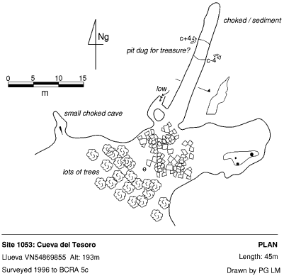
The left hand entrance is a fossil remnant that may draught and contains
a deep pit half way along its length. Beyond the pit, the cave is choked
with a mud and stone conglomerate. The right hand side is a choked chamber
with no apparent way out.
The 4m deep pit chokes but there is a theory that it may have been dug as a defensive measure - there are possible socket holes down its side. It has also be said that the pit was dug for treasure. The most plausible theory is that the pit was dug for iron oxide nodules, some of which can be seen in the shaft. During re-exploration at Easter 2006, bear scratchings were noticed and various organic growths: algal growths - blue/green and purple/pink. There were also sticky globules hanging from the roof, presumably to catch flies and a black "pictogram".
Reference: anon., 1995c (logbook); anon., 1996a (Easter logbook); anon., 2006b (Easter logbook)
Entrance pictures : yes
Underground picture(s): yes
Detailed Survey : 1:500
Line Survey :
On area survey :
Survex file : yes (Amended magnetic declination December 2013 to align with Eur79 grid and coordinates altered to fit ETRS89 datum, April 2014.)