Updated 28th February 1998; 19th February; 17th December 1999; 21st January 2001; 12th May, 30th October 2002; 20th December 2008; 6th January, 5th, 11th October 2011; 25th September 2012; 4th March, 24th April 2013; 5th January 2015; 10th February 2016; 30th June, 22nd September 2018; 24th May 2021; 14th November 2022
This site has great potential as it has at least 3 levels, the lowest of which carries the water which resurges at site 0791. Diving before 2011 had reached 340m in, at a lowest depth of -82m. Diving in 2011 significantly extended this (see below).
The obvious entrance lies 5m above the
road, 40m west of a track down to the river. The easiest route to the cave is to walk a few metres up a track on the northern side then turn left along a faint path through the trees. The entrance is usually strongly draughting. A temperature of 11.9C has been recorded. A second entrance is site 5250.
A stooping walk-in leads past
1930's graffiti on the right, past another entrance coming in from the left
and then slopes down to where the river might be heard in wet weather. The
route passes holes on the left where the water can be seen below and reaches
a very steep slope up with a fixed ladder.
A wriggle up through an enlarged squeeze
enters a higher series, 6m above. Up to the right, and right again a large
chamber lies over the previously traversed passage and contains some formations.
The calcite wall at the start of the chamber has seen climbing (by the
Catalans?). This was re-climbed in the summer of 2002 and the bolted route
ended about 20m up with 3m of passage and a dead bat.
At the far end of the large chamber, a small hole on the right leads to a
5m vertical climb up into a smaller chamber with nice stal in the centre
and some helictites on the northern wall.
Turning right and then left at the top of the rope climb enters an oxbow
to the main route. After 10m, on the right, a squeeze over blocks enters
small passage which finishes at a small climb up. The route swings down to
the left and just before meeting the main passage, a slither up a strongly
draughting, sloping passage enters a small chamber and a narrow, draughting
continuation. This carries on beyond station 17 and needs pushing.
Back at the top of the rope climb, the usual way on is up a 2m climb and
along a pot-holed passage. An oxbow links in on the left and, after 20m,
the oxbow passage mentioned above enters on the right. The stooping passage
continues to a hole on the left into a 15m high chamber with a mud floor.
The far end has a squeeze up into a small chamber. The northwestern side
of the chamber slopes up to an alternative route through to the end. This
is joined by crawling through into a strongly draughting passage with knobbly
limestone and meeting the alternate route at a corner. There are a couple
of links down to the alternative way along its length. The route then slopes
down to a stooping height area with a pit straight ahead and a choked passage
to the right.
On the left are the small entries to Fool's Paradise, discovered at
Easter 1997. This enters a hading rift which pops out in the side of a large
passage. A rope descent of 3m enters over 150m of "handsome-sized" passages.
There is a bolt route which needs following.
Back in the main passage, following the right hand wall down to the left
in a high rift leads to a drop into water;
following the left hand wall leads to a climb down over boulders to the same
water. At the top of this climb, a roomy passage back under the main route
drops down over a watery pit to a sandy-floored passage (sumps in wet weather)
to a muddy pool with slippery climb to nowhere above.
Back at the water, the flow emerges on the left and sumps again to the right
in a roomy chamber. Straight ahead, the route leads to a large chamber, meeting
the final large sump pool beyond boulders. The chamber slopes up to the northeast
to a T junction. On the right, a roomy passage becomes too small to the east
after 70m, after passing through a knobbly limestone lens. The left hand
passage at the T junction drops down to tight rifts and pools. Standing at
the top of the sump chamber slope an interesting holes are seen on the western
wall which were climbed and bolted to at Easter 97, but end at a boulder
choke.
A climb up on the left of the northern slope ends high up above the sump
pool at a bolted traverse, carried out during the summer 1997, which heads
off above the sump but chokes as it swings back to the west. A bouldery passage
also heads back south and ends at a pitch down to the climbs high up on the
southern wall of the sump chamber. The northwest limits of this high level
route end very close to breakdown passages in Cueva Sebo
(site 1099) above.
The cave was entered at Whit 95 to look at the final upstream sump. This
was found to have thin nylon line tied off. The resurgence, Cueva del Molino (resurgence) (791), was dived for
50m.
In August 1996, Rupert Skorupka dived at the final sump after an easy 20
minute carry. The old 2mm line immediately dips down into a superb, arched
tunnel, 3m high by 5m wide. Within 70m, a depth of 22.5m had been reached
and the line continued steeply down to at least -30m.
The dive was continued over Christmas 96. The thin French line ended at a
lead weight at about -28m. The sump continues in a fine gravel-floored tube,
the walls sometimes not seen in the 6m visibility. At -50m the smooth wall
of a massive swirl-chamber can be followed around in a semi-circle, where
a further slope leads down to -55m. The floor levels and rises over a pile
of sharp edged flakes. The passage then appears to continue level at -50m.
The January 97 limit is therefore 150m from base and -51m.
The dive was continued at Easter 97 to a small ascent up a boulder slope
to -47m where the passage sloped down in a massive arched, sand-floored tunnel
with the occasional slab. Beyond the 190m mark the passage appears to close
down but 20m back, the right hand wall slopes down over a massive boulder
slope, with far wall and roof out of sight. At 200m from base, a depth of
60m is reached. Beyond, the boulder slope continues sloping down, the blocks
petering out and at 260m in, a depth of 70.5m is reached. The boulder slope
is seen to rise ahead.
The dives during the summer, 1997, increased the dive length to 340m after
passing a deep point of -82m. The passage continues.
In 1999 a series of dives to extend the cave failed due to a combination
of various factors: poor visibility, equipment failure and unbalanced bottles.
Diving continued with little progress due to poor visibility
and flooding but, in 2003, he extended the dive to 390m at -82m.
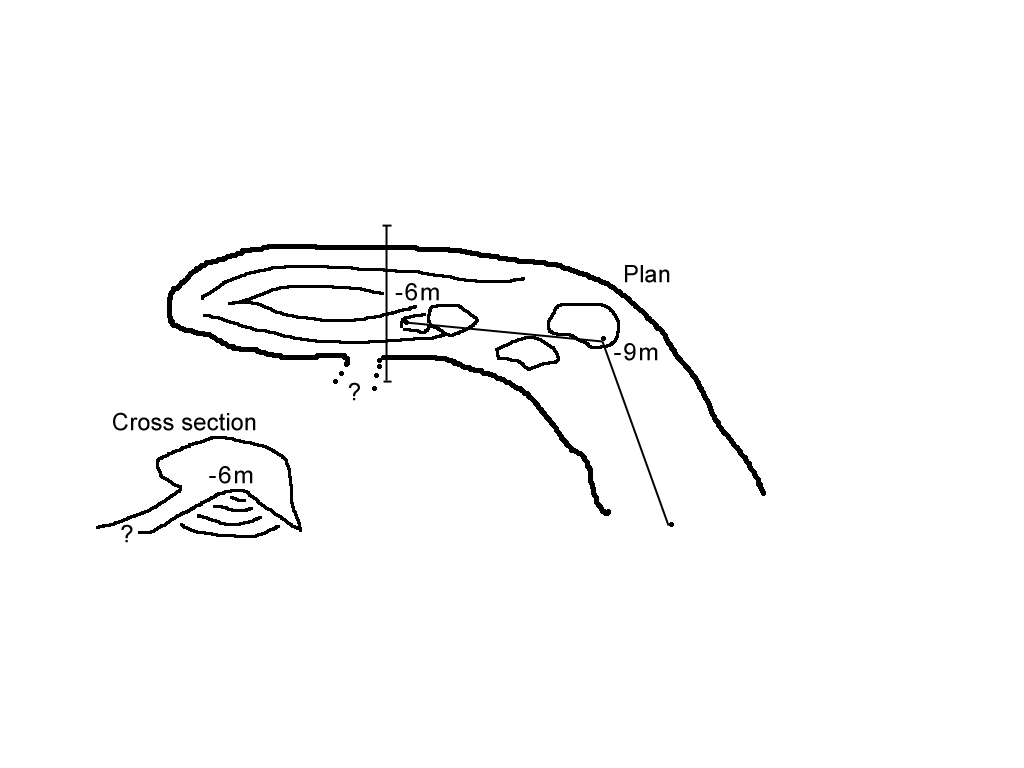
The underwater upstream route was significantly extended by Chris Jewell and Artur Kozlowski over 2 dives near the end of August 2011. Rebreathers were used by both divers. On the first trip they reached -95m (after the water level had risen). On the second dive Chris surveyed the area of the connection with Rupert's dive while Artur pushed on to a 30m upward shaft. He ran out of line after 400m, reaching a depth of -12m, having passed through -93m. Artur's 6 hour dive profile can be seen in a discussion on the Irish Technical Diving site. These dives produced 645m of new (underwater) passage and the sump has been dived for a total of 885m, still continuing. The deepest point is around -93m (depending on the water level) which is 122.5m below the entrance and at an altitude of 96.6m. An account of the 2011 dives is available.
A long solo dive by Chris Jewell (supported in the base pool by Laura Trowbridge) in July 2012, passed Artur's limit by
(an unsurveyed) 40m but it appears that the main way on has been missed although much searching occurred at -6m. The end of the line is now 925m from base.
A log of the 2012 dive is available along with a combined survey.
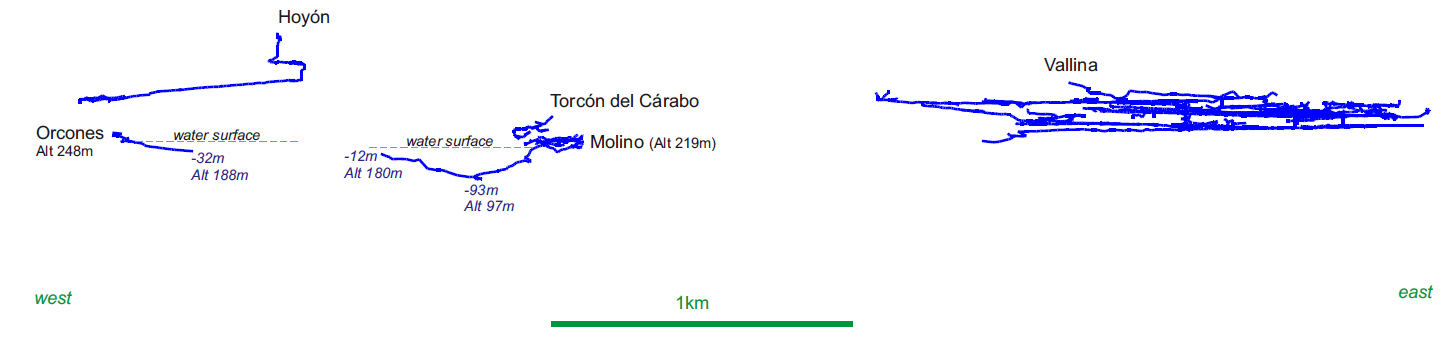
The upstream passage is heading in the general direction of the Sumidero de Orcones (3602), a site at Bustablado being explored and dived by French cavers. An area map with centre lines (only partial for Orcones) and a section through Molino and Orcones (again only partial) has been plotted. According to Guy Simonnot (pers. comm. October 2011) it is likely that the flow in Molino can be accounted for by Orcones and "the collector - Cantu Pasillo Encarmado." He continues, paraphrased, for cavities such as Vallina we may need to think about another source (resurgence) - which would suit me better geologically." An updated area map, with Orcones dived closer to Molino and a supposed inlet (from Torca del Hoyón?), was also received.
Articles produced as part of Sedeck meeting in Ramales, 2014 (Papard Philip, Corrin Juan and Smith Peter, 2014 and Simonnot Guy, 2014) also examine the role of Molino as a possible resurgence for Orcones and systems to the south of Bustablado (on the west flank of the Asón).
All the dry passages described above are above the river series which runs
through the cave. This aqueous series of passages is described coming downstream
from the final chamber complex.
Sump 1 is a delightfully inviting sump. A low section through blocks soon
enlarges in a sloping chamber at - 9m. At 40m a choke is met and the way
on is down a steep rock slope to a cobble-floored chamber at -20m. The sump
then takes the form of a big tube in perfect black limestone, gradually ascending
to surface after a total of 130m in a shingle-floored pool. The downstream
section is too small to explore in a dry suit but is only a short distance
to the next sump.
Sump 2 was explored upstream, but described downstream as 37m long and 6m
deep emerging in a beautiful deep blue swirl pool, 5m in diameter. This is
the hole seen below the rope climb.
Downstream, 25m of passage leads to sump 3 which is also a very clean dive
with an abundance of fossils. The deepest point is at -8 at a small arch
over cobbles and it surfaces after 40m in a point where it is possible to
climb down to water from the higher level.
About 30m of open, potholed streamway slopes away to a bouldery area which
has a couple of unsurveyed sections and then the passage bends to the right.
On this corner it is likely that the very first link from the high level
enters. The streamway continues with the water on the right for 20m until
a deep, long sump pool is reached. This point is 140m from the resurgence
(site 791).
During a significant flood, at Easter 2013, Rupert observed that the Molino stream was swollen and very milky (from snow melt?). Comellantes stream was also swollen but quite clear (from flood water). Looking at where the snow remains: Molino water is coming from the Porracolina (S) side of the Bustablado valley and Comellantes accounts for all the drainage to the north of the Bustablado valley, ie Vallina, South Vega and unknown systems.
Loriol B de, 1959 has a description which needs translating. The French
survey appears to be at a different angle from the new survey.
Degouve de Nuncques Patrick et Simonnot Guy, 1989 indicates that the
Spéléo-Club de Dijon were exploring the cave from 1958 to 1961,
April 1979, August 1980 and April 1985. The downstream sump was dived to
the source in 1979 and the upstream sump for 40m (to -22m) in
1980.
The cave has been mentioned as an archaeological site with pottery sherds
and human remains. More details can be found in Ruiz Cobo Jesús,
2007 and Smith P, Corrin J and Ruiz Cobo J, 2008.
Link to entry in the Cave Diving Sump Index.
References: Loriol B de, 1959; material in file; Degouve de Nuncques Patrick et Simonnot Guy, 1989; Corrin J, 1994b (survey); anon., 1995b (Whit logbook); anon., 1996b (logbook); anon., 1996c (Christmas logbook); anon., 1997a (Easter logbook); anon., 1997b (logbook); Corrin Juan, 1998 (survey and photo); García José León, 1997 (survey); Algueró, A, Martinez, C and Garcia, A, 1998 (survey and photo); Corrin Juan, 1997c; anon., 1999c (logbook); Corrin Juan, 2000; anon., 2002b (summer logbook); Corrin Juan, 2003b; Ruiz Cobo Jesús, 2007; Smith P, Corrin J and Ruiz Cobo J, 2008; León García José, 2010 (Volume 1 and Volume 2) (survey); anon., 2011d (summer logbook); pers. comm. (Oct. 2011); ; anon., 2011e (autumn logbook); anon., 2012d (summer logbook); Corrin Juan, 2013a; anon., 2013b (Easter logbook); Papard Philip, Corrin Juan and Smith Peter, 2014; Simonnot Guy, 2014; Simonnot G, 2016; Simonnot G, 2018; Simonnot G, 2022
Logbook dive entries : 2011 : 2012
Entrance picture : yes
Underground picture(s) : photos from 1977 : photos from 1996 and 1997 : photos from 2002
Video: Diving, August 2011, with Chris Jewell and Artur Kozlowski (YouTube) : Chris Jewell interview 2012 (YouTube)
Detailed Survey : 1:1000 (without the 2011 extension) : 2012 40m upstream sump extension sketch : combined surveys (to 2012)
Line Survey :
On area survey : 2011 area map to (partial) Orcones : 2011 section with partial Orcones : after Guy Simonnot communication (October 2011)
Survex file : Molino (Amended magnetic declination December 2013 to align with Eur79 grid.)
Molino with Sebo, Hoyon, Vallina and Orcones
Passage direction rose diagram: 30/6/2018