The Four Valleys System (Sistema de Cuatro Valles) has 18 entrances (November 2023). Cueva de la Hoyuca in Riaño is the major segment having the following entry points
The other linked entrances into the Four Valleys System are
- in Riaño
• Cueva
de Riaño (0105) with the dive site at the Riaño resurgence (0575),
• Cueva-Cubío del Llanío (3234) with the Sub-phone entrance (4536)
• Fridge Door Cave (1800) with Boob Tube (5000) entrance and Vaca Bypass (5368)
- in Llueva
• Cueva Llueva (0114)
- in Matienzo
• Cueva de Carcavuezo (0081) along with alternative entrance site
3895
• Torca la Decepción (0252) with the lower entrance, site 4732 (preferred)
- in Secadura
• the collapse cave behind the
resurgence at Los Boyones (0117) in Secadura. This last site has been water traced from Carcavuezo and Hoyuca but there is only a small amount of bouldery "passage" for cavers to traverse. (The length of 100m has not been included in the length of the 4 Valleys System but the depth is calculated to the water surface at Los Boyones.)
An incomplete description follows. Some sections are possibly described twice,
and the whole account (especially the entrance series) needs rationalizing as part of the re-survey.
[Easter 2010 notes (for Dog Series; Vampire Gallery; etc) need adding from the "Matienzo Underground" descriptions and the sheet in box]
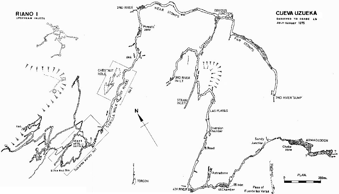
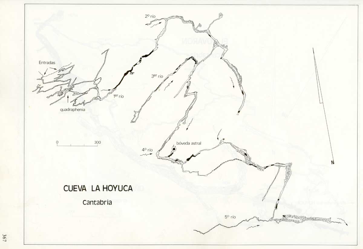
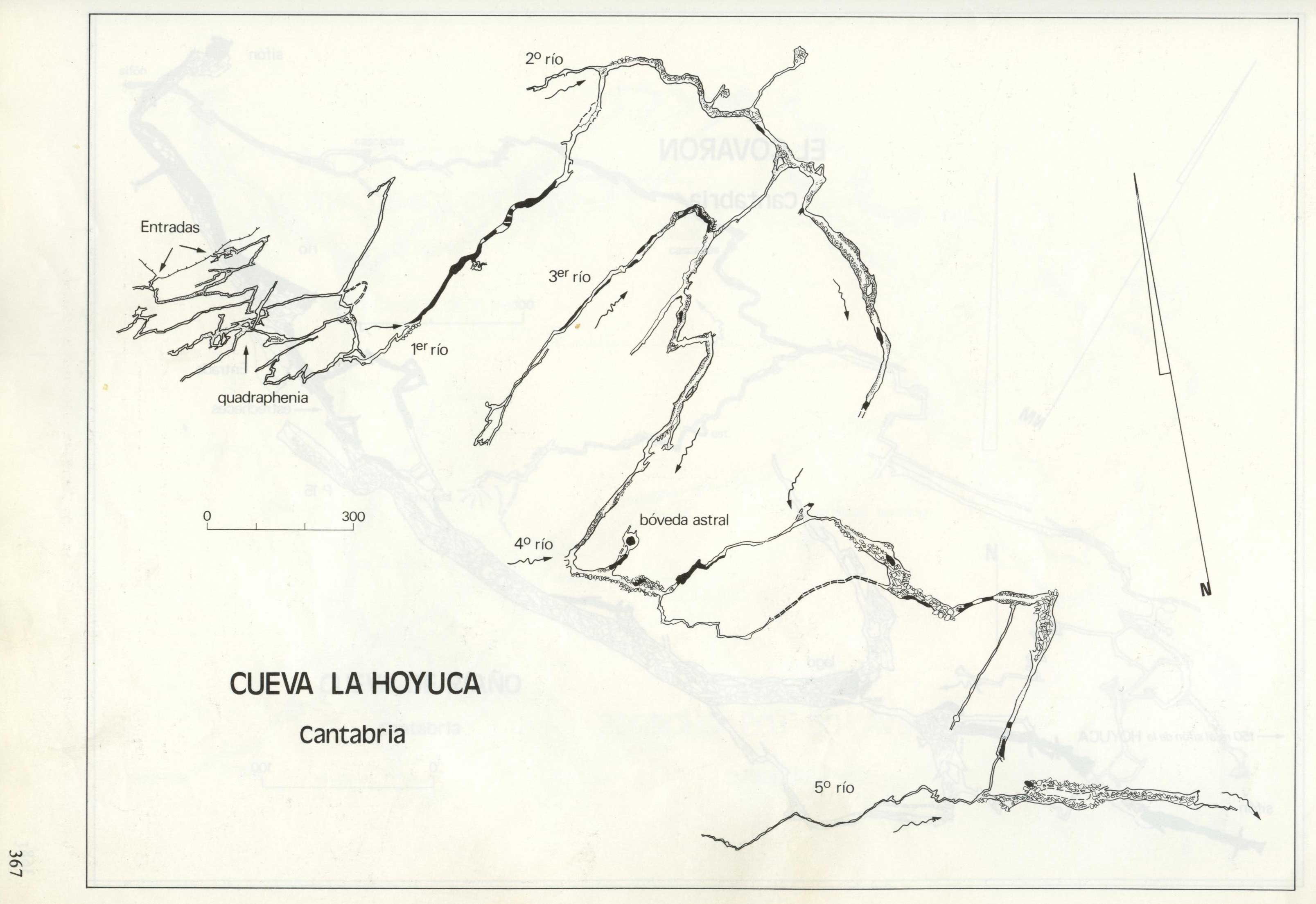
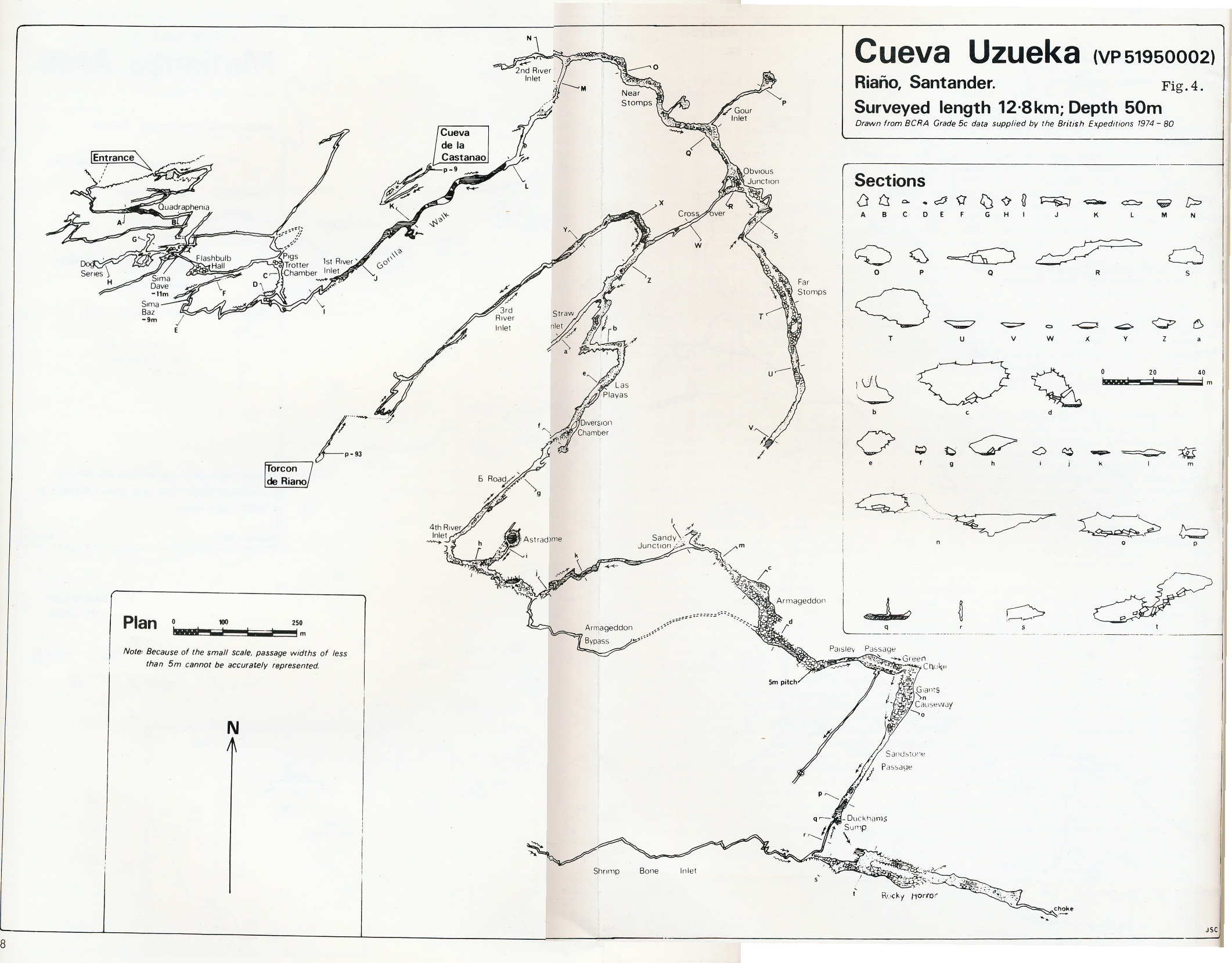
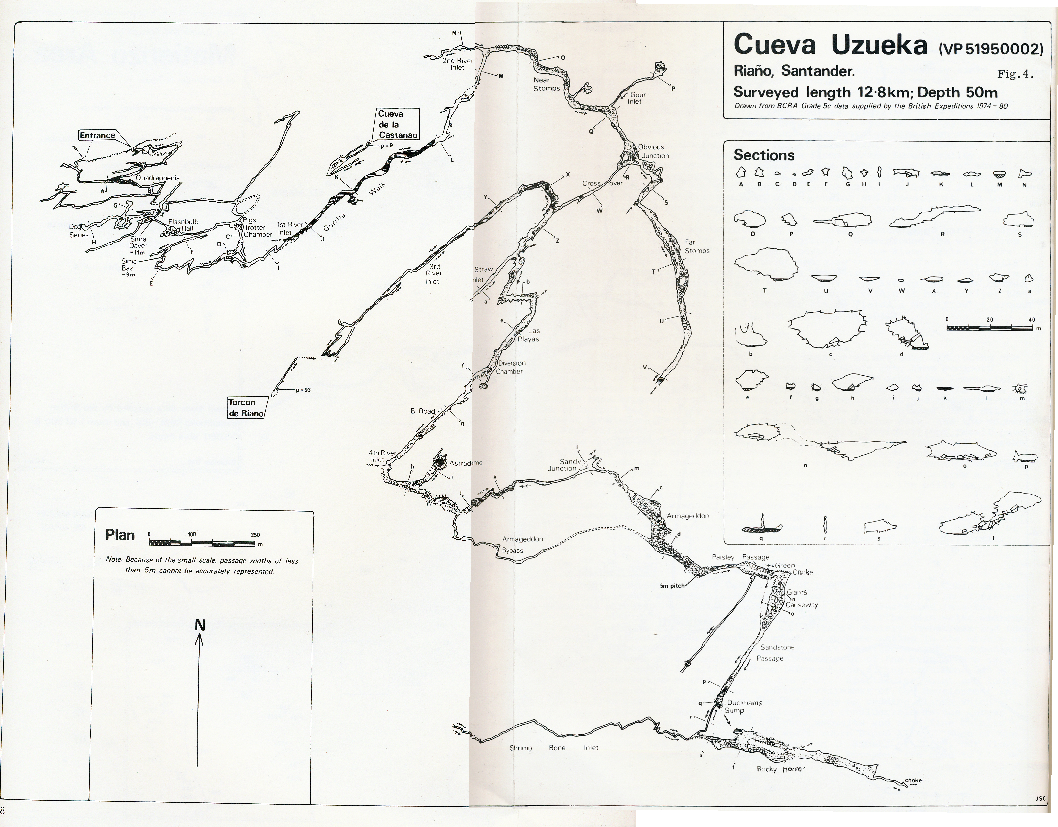
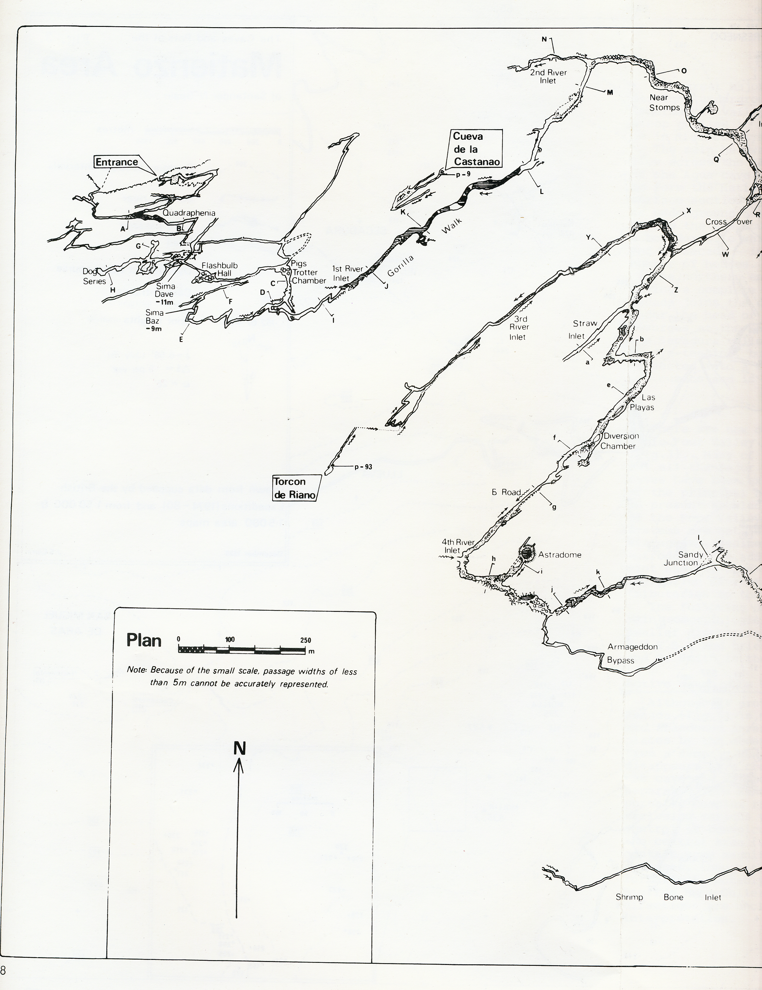
A cave of great variety, potential and in places, complexity. Cueva de la Hoyuca is the major segment of the Four Valleys System (line survey). The cave continues to yield extensions, not just at the end, but in the entrance series which most people had previously neglected in their hunt for glory.
All of the water met in the cave eventually joins with some of the water from Cueva de Riaño (105), the water from Cueva de Carcavuezo (081) and then enters Cueva Llueva (114) and flows to resurge at Los Boyones (117) in Secadura. A diagram of the overall hydrology by Terry Whitaker can be seen here. A more detailed diagram for the entrance series is being prepared.
If the route through the cave is known then a quick trip from the original entrance to the end of Trident Passages and back will take about 9 hours. The route from the original entrance sumps in wet weather in at least two places. The Giant Panda entrance (#2961, opened up in 2008) may cut a couple of hours off this time and may provide more "all weather" access. For example, it was used at Easter 2008 in high water conditions when new explorations were taking place in the Gour Inlet extensions. After being closed for a couple of years, the Giant Panda entrance was re-opened at the end of December 2019 but is now considered still unsafe at the head of the first pitch (September 2023).
In August 2023, the Torca la Decepción (#4732) entrance in Matienzo was used to visit the Astradome, via Armageddon. The round-trip took about 8 hours. All subsequent trips into Armageddon, Rocky Horror and Trident Passages areas have all been made through the Decepción entrance.
Route through into Cueva Llueva
Five entrances are known. The Church Entrance, only discovered in 1986, lies in a wooded depression next to the track, 200m below the church. A 6m high entrance drops down into a small passage. A short stretch of hands-and-knees in deep mud spoils the passage before it emerges into Quadraphenia at the first dog-leg. The unfortunate fact about this entrance is that a local farmer has used a nearby slot as a means of getting rid of manure. The deep mud may not be what it seems and perhaps should be checked out from inside the cave before attempting a trip through. Reference CE documents the gran depósito de estiércol and the possible consequences. During the 1994 recovery, an old door was used over the mud and this is likely to be still in place. However, a trip through in October 2015 described the passage as "crawling mostly over sand and gravel with no sign of cow shit. At a corner before the connection the floor was wet mud but not smelling."
The "old" entrance (photo) is a couple
of metres up a wooded slope at the bottom of a maize field. When visited in the summer 2019, a dairy museum had been established next to the entrance. A short, constricted,
draughting entrance crawl (which was collapsing at Easter 2010 and Easter 2011), with drops below, enters a small chamber. Straight
ahead, a descending passage drops to a calcite-floored chamber and a further
short slide down enters a maze of rifts where carbide arrows point back towards
the entrance. A short climb up and a tight sideways squeeze
(photo) pops out into Quadraphenia.
(Back from the entrance chamber, a climb up bypasses the tight squeeze and
drops down into Quadraphenia). (At the top of the climb a tube was pushed back towards the surface to a stal choke in 2010.) An alternative route through to Quadraphenia
is from the second entrance chamber, where a climb up straight ahead leads
to a crawl and climb down into the start of Quadraphenia, bypassing (and
passing) the tight squeeze.
(A Roof Passage in the entrance series was surveyed August 2002 -
length 108m, and needs a write-up).
Quadraphenia (from the sideways squeeze): The passage enlarges from a slight stoop almost immediately and the next
560m is a trot along sandy-floored tunnels (photos 1 2).
Large junctions (one of which brings in the Church Entrance passage)
are negotiated by four left hand turns until a final right hand turn leads
down to a low section into the stream in Pigs Trotters Chamber with
its fine roof pendants. Continuing downstream a short crawl over black cobbles meets a second stream emerging from a sump on the right. A sand slope up opposite quickly closes down. Heading downstream, a smaller inlet passage on the right is followed as a crawl on cobbles. This inlet ends with a wet flat-out crawl on gravel which sumps in wet weather and is often half full of water. The far end of this low wet section often has to be dug out after the winter. The crawl is abandoned by slithering up into a small chamber on the left. A series of phreatic chambers is entered which are connected by short crawls. Some hundred metres of joint-aligned walking follow, and this ends at a small boulder choke where the only way on is down into the low and wet Punk in the Gutter which lasts for only a few metres. (At Easter 2011, a possible dig was investigated further down on the right of the cobbled streamway which may have bypassed the crawl. A long term effort would be required.)
First River Inlet is passed on the left and the way enlarges. The
stream is left to clamber over large blocks and the only way to regain the
water is down through a narrow slot.
The next 1000m of passage - the Gorilla Walk - is generally stooping-sized with a metre or more of water to wade through or crawl in. After around 200m a major unnamed inlet is met coming from right. This water emerges from a sump after a short distance. Another 250m on downstream Windy Inlet drops into the water at a point where it is possible to stand up. This is the bottom of the Giant Panda (2691) entrance, which is the preferred way in to this point for those who can fit throiugh a tight squeeze. The water soon exits into a sump on the right and the main passage continues over cobbles under some unclimbed avens. The direction of water flow is reversed in this section until a small inlet is passed on the left. The passage enlarges at the start of the Phreatic Zone where the main walking size route turns sharp right, then back left. It is also possible to continue straight ahead into a wide bedding crawl making up the left hand side of the passage at this point. This bedding can be followed all the way through, or the walking route followed into boulders where various climbs up allow access back into the bedding route before the final deep pool is met (photo B5 in the Summer 2010 set). Off to the left part way along the bedding are a pair of large unclimbed avens. Off to the right of the walking route a series of phreatic crawls in water are found, leading to the Zoological Gardens.
Another 100m on in the main passage a major junction is met.
Second River Inlet - the route into Cueva de Riaño (105) - comes in from the left while the way on is to the right. The direction of flow has reversed again by this point and the way on is once again downstream. Almost immediately after this junction a second inlet is met on the left. This supplies the majority of the water in this section of the cave, but a way upstream has yet to be excavated up this significant inlet. The route for the next 500m is obvious, through the Near Stomps, a large stream passage where the route is mainly over large sand banks. A small inlet is met flowing out from under rocks on the left near the side passage to the Hidden Aven. Next Gour Inlet is passed on the left, the water flowing across cream coloured gours into the main streamway and, 100m further on, Obvious Junction is met up on the right. The river is left behind as twin passages unite at the start of Crossover Crawl. This is a generally low, sandy passage which ends after 160m at a walk down into the Third River.
Downstream, the next 540m are easy walking in a large streamway, passing several smaller side passages. The largest of these, Straw Inlet, is straight ahead at a left hand dog leg. After two further sharp bends left and then right, the entrance to 96 Passage is seen up on the left. The passage then enlarges considerably at Las Playas, the last 200m or so being on sand before reaching Diversion Chamber. Two inlets can be entered on the left from this chamber. Sloppy Inlet starts as a crawl in water from a pool under the left wall, and Diversion Chamber Inlet can be found in the back left corner of the chamber. The main passage is blocked here, but a small passage with deep water (B Road) sets off on the right and the large, main route is soon rejoined on the other side of the collapse. Another 140m further on 4th River Inlet is passed on the right at a bend and, after another 100m of walking, the entry to the Astradome is seen on the left up a sand slope. By continuing downstream, 44 Chamber is reached and 95 Inlet is passed on the right. The streamway then becomes small phreatic passage for 340m to Sandy Junction, where the stream which was left behind at Obvious Junction enters on the left. The way on is downstream to face a boulder choke and the entry to Armageddon.
By continuing downstream, 44 Chamber is reached and then the streamway becomes small phreatic passage for 340m to Sandy Junction, where the stream left at Obvious Junction enters on the left. The way on is downstream to face a boulder choke and the entry to Armageddon.
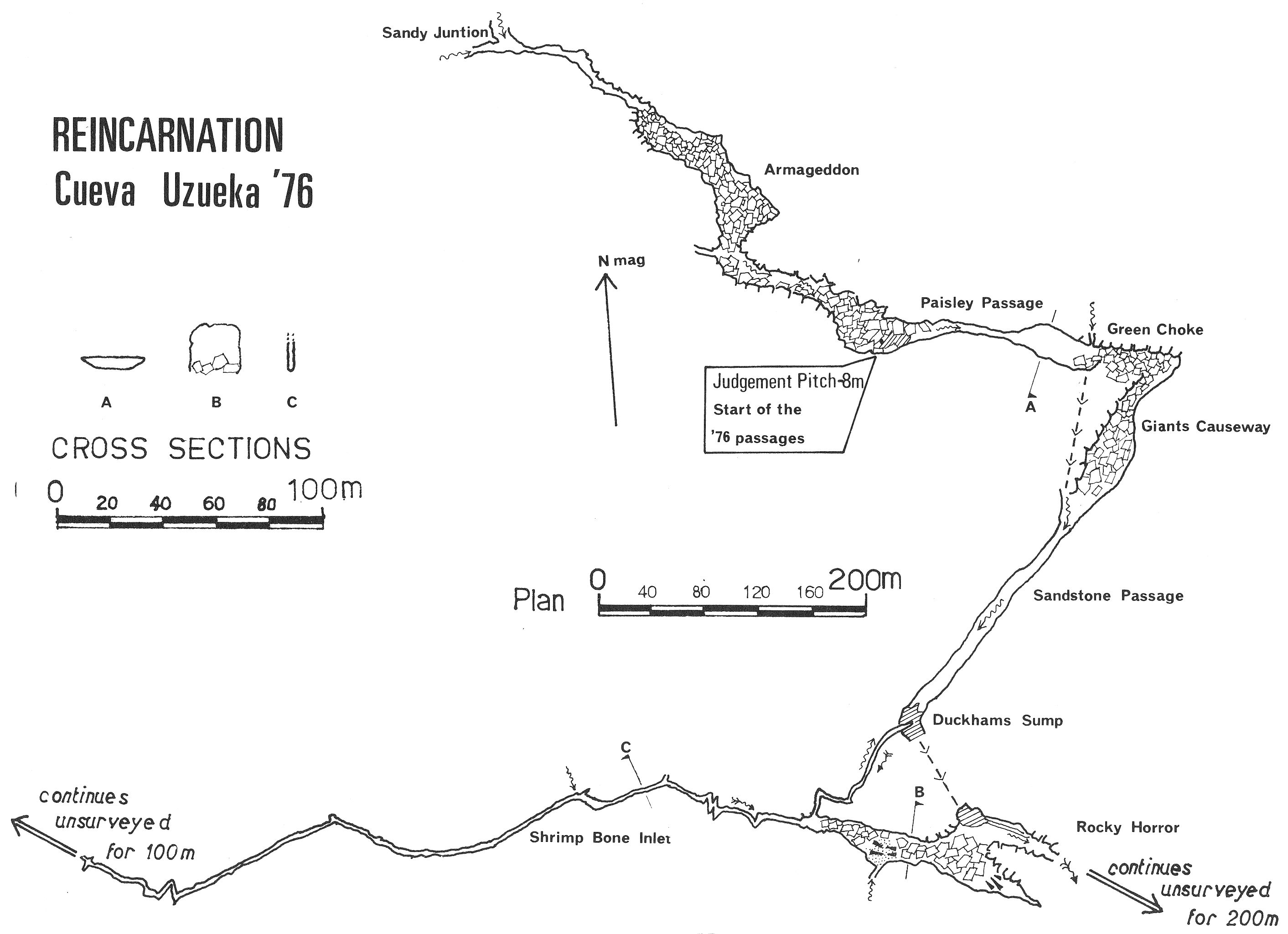
Armageddon is a 260m long heap of boulders, the first 20m of which
are negotiated by following road works bunting (still there?) through the
pile over drops into the stream below. Then by striking out and up (generally
to the east) the boulders are left temporarily for a sandy walk, passing
a large passage on the right - the entry to the Armageddon Bypass.
A clamber down to stream level is then required and finally a climb to the
east leads to a short SRT pitch (with loops) - Judgement Pitch - has (January 2024) replaced the original ladder pitch of 5m down through precariously perched boulders
to the stream. (One or more trips have negotiated Armageddon without finding
the ladder). This was the area of connection to Torca de la Decepción (0252 / 4732) in the summer, 2022.
At Easter 2023, at the Armageddon choke, a "new section of passage was entered high in the roof, about 50m back from the choke." "Footprints led up to it but not into it from the other end."
Armageddon is left behind and the water followed down into Paisley Passage, a 20m wide and 4m high bedding plane. The passage terminates after 200m at Green Choke with the water seeping away on the right.
The way through is over fallen slabs and scree to the left and all routes unite as a slither up to the head of a roomy bedding plane - the Giants Causeway. A walk down over large slabs leads to a pool and the stream is regained. The water is followed for 160m over sandstone blocks in a bedding 3 to 4m high. The water drops over a small cascade and the next 150m are negotiated in deepening water as Duckhams Sump is approached. The route is along the right hand wall and then out into deep water for 5m towards the sound of falling water. With little enough airspace at the best of times, muddy swirls on the roof show that the whole area sumps. The exit is up through a body-sized hole in the flat roof into an awkward rift which is followed upstream for 100m. It is then possible to climb up on the left into an area floored with large level-topped blocks and sand. The bedding becomes increasingly larger until a descent is made to a high inlet on the right. This marks the start of Rocky Horror.
Route finding on this 200m long pile of immense blocks can take a couple of hours though some routes have been marked. It is generally best to keep fairly high up on the right of the passage, leaving the stream down on the left. Passage walls eventually appear out of the gloom and the floor gradually reaches the roof. The stream can be found by dropping down on the right a few metres back from the end. A comparatively small and well decorated passage meets the stream after 80m. Re-exploration and becoming familiar with the area occurred at Easter 2023.
A draught whistles out between boulders both at stream level and at a higher
level and one route through the unstable mess was pushed in 1986. The loose
connecting choke joins with the 1985 Extensions in Cueva
Llueva (114) on the upstream side of the upstream sump. The route appeared
to collapse behind the explorers on the second trip through.
Strangle Wanking Passage, (first explored and surveyed from the Cueva Llueva, but now more easily reached from Carcavuezo entrance) was pushed through the terminal sump by Dave Garmin in August 2017 into a bouldery area where orange string had been left from a previous exploration near the end of Cueva Hoyuca. The sump has a line through, bolted at each end, and has been described as a 5 - 6m free dive. There is a dangerous rocking boulder on the Hoyuca side which requires some attention. A video of the dive, filming and exploration into Hoyuca has been edited.
The survey in the area appears quite accurate apart from the z axis.
Other passages are now described by working through the cave from the main entrance
By dropping straight down in the entrance.................. Other bits off the entrance series, Lank?
At Easter 1994, a route from the 1st chamber in the old entrance to Quadraphenia was tackled up. This involves a 5m climb up and a climb down and cuts out all the complexities of the old route. The route was detackled after the summer of 1994 and is not recommended for rescue purposes.
A small passage off Quadraphenia, just after the first dog- leg, leads to daylight above, although this pitch has not been descended. It has been seen on the surface as site 2872.
After the junction leading to the Church Entrance, at the next double bend, a walking-size passage on the right soon drops to a low, continuing streamway, pushed a short distance downstream in 2008.
The next junction in Quadraphenia, about 80m further on, is where a normally dry stream bed crosses the passage. To the west, Tiler's Way is about 400m of smallish phreatic passage that can be followed to a number of branches, all of which choke. The northwestern end (batch 0107-15-01) comes close to the end of site 718. Both ends here look very similar. To the east from Quadraphenia the stream sumps after 20m.
At the same junction, a 6m pitch up (re-bolted in 2008) leads to Roofer's Way, about 200m long to where it becomes too tight.
In the next 20m of Quadraphenia, up to a left hand bend, two passages on the right soon become too low. A narrow rift on the left leads to an apparent sump pool, with a possible continuation with low air space as there is a draught.
Forty metres after the last acute bend in Quadraphenia, a 4m pitch up* leads to a complex area of rifts also reachable by pitches down beyond Flashbulb Hall. A long passage shown on the early drawn survey has not been relocated but may be a low crawl following a stream passage upstream out of the area. Pull-up Passage is the first route on the left on entering the maze and appears to warrant further investigation. It is reached by a short ladder pitch, but this can be bypassed. A climb up over a sump requires combined tactics to reach the continuation of this passage. Opposite the 4m pitch up, a stream issues from a
sump and flows along Quadraphenia for 50m. (This stream was dye tested at Easter 2009. Dye dropped into the sink below Fuente de la Cuvia was seen here 30 hours later.)
*The ladder is in place but is in poor condition. It was probably installed in 1991 so was re-rigged and an SRT rope rigged for protection in summer 2009.
After another 80m, a passage on the right of Quadraphenia is an oxbow. Part way along, climbs down rifts drop into a low, wide stream passage, also reached down a slope at the next junction in Quadraphenia. The second side passage in the oxbow was dug through in 2008 into previously entered passage, assumed to be part of the Flashbulb Hall series.
Next in Quadraphenia is a climb down at Marathon Junction. Here, to the left, is Marathon Passage - a mainly walking-size passage taking a small stream and draughting in, presumably towards the surface. At the end, climbs and small chambers are largely calcited up.
Climbing up straight ahead at Marathon Junction, an easy going, sandy passage leads to a climb down to Pigs' Trotters Chamber, but the normal route is right to Gloomy Chamber and Pigs' Trotters Chamber.
On the right hand wall of Pigs Trotters Chamber is 100m of minaret-type passage which leads up to Flashbulb Hall. On the left about 50m before Flashbulb Hall several routes lead up into a chamber with a pitch down into an unsurveyed and incompletely explored section - God Knows Passage? In this area a route connects to Flash Bulb Hall by a traverse ending up behind the big block in FBH.
Various routes up rifts in Pigs Trotters Chamber to the left of the route to Flashbulb Hall lead to a high level passage, Wardrobe Passage. At the start of Wardrobe Passage, a junction on the left immediately reaches a further junction. On the right, a low passage ends at a twisting aven carrying a good draught. To the left at the junction, a rift passes back over Pigs Trotters Chamber while, straight on, a passage ends at a choke. Two routes over traverses lead to a low crawl continuing low and wide. A pitch down from the traverse connects to the main route downstream from PTC. These areas were investigated at Easter 1994 and again in 2009 when the survey was extended. At Easter 1997, the pitch at
the end of Wardrobe Passage was dropped into a fine rift in which
was found a survey station note from 10 years previously, linking with God
Knows Passage. (Survey notes have disappeared?) Toby's account of his explorations (14/5/2011) follow:
Things sound a bit confused in that area but I'm certain of most of the details of what I did. Unfortunately I can't remember, corner by corner, exactly how I got to the start of the traverse. I was at roof level in the traverse I did and there were a couple of big flakes stuck in the rift that I walked on. Where ever Chris was can't be where I was as there was no more up to go! I think it was a flat bedding roof.
I'll talk (write) my way through it and see if it clicks with anyone. We did this on the same trip that we bolted/climbed the aven which Jane found and somebody has since shone a disto up. We did survey that aven and the chamber above but I've no idea what happened to the notes. Maybe Lank can remember?
Go along Quadrephenia and enter Pigs Trotter Chamber. Keep in the water, with the slope up to all the other higher stuff on your right, and stop where the main passage drops to a stoop/crawl under the wall. (ie stop just by the exit of the chamber where the way on into the rest of the main cave is, with Quadrephenia behind you). The wall is nearly vertical, leans out very slightly. This is where the 2 ladder long pitch I dropped enters. I landed at the very left hand side of the stream. Bolt up about 18m and you will find my bolt!
To get to the top of that pitch, the start of the traverse I'm talking about, stand in the same place and turn right. You are now facing the slope up to the higher stuff, with a tall wall on your left. Go up the slope and climb up behind the Pigs Trotter formation. At the top a passage heads off back over the end of the chamber, crossing over the stream at 90 degrees. You can't see down to the chamber or the stream as you are in a solid passage. Follow the passage for a short distance (the distance that equates to the horizontal distance between where we were standing in the stream and the climb up behind the trotter, It's not far. Now things get vague in my mind. I can't remember if there is something off to the left here (Jane thinks she remembers a crawl) or if the left hand wall opens out, but the pitch is just on the left here. It's a narrowish rift with a big flake jammed in it at floor level. I laddered down the narrow rift before the flake. It's not tight as I recall, just a bit narrow for the first metre or so then widens until you drop out of the roof of PTC down the wall I've mentioned and land at the left hand side of the stream. (I recall the stream as flowing OUT of the chamber under the wall at this point, ie on into the cave, but Jane thinks it runs INTO the chamber here ie flowing towards Quadrephinia, if she is right then my description of downstream end of the chamber is wrong and could be the source of confusion. If so, sorry for wasting peoples time).
The traverse starts with a step out onto the flake. There may be a very short section of bridging over the rift to attain the flake but it's not far at all. I may have put a sling around something at this point for protection (not really needed but I had the gear with me and it wouldn't have been clever to slip off having seen where I would land!) It's more than likely that someone will have just strolled over it without any trouble. Torben would have whizzed straight across with no problems at all, if this is where he has been. A couple of steps on the block lead to a right hand bend with another flake as the floor. There were footprints in the sand on this flake but I didn't notice any obvious marks before I got to this point but they may have come in the way I did. A few metres along here there is a low bedding crawl off to the left. This crawl had a sand floor and there were 'tram lines' going along it, very obvious. It's possible that the footprints I saw on the flake had come in via this crawl. As I was somewhere which was known I turned around thinking we would be able to sort out where the crawl went and who had done it when we got back to the bar. Didn't work out like that though! The traverse continued but I didn't and can't remember much about it. I thought I was in the top of an old vadose trench which was following the stream route below me in Pigs Trotter Chamber. We were hoping to find stuff going the other way, the elusive higher level over the Gorilla Walk and Jane was shouting to me about having found an Aven with a draught and possible passage going off into glory visible at the top so it was a no brainer really! And, of course, that ended up all choked.
On the way out we came back down the climb behind the trotter, with the wall immediately on our left. We followed the wall across the stream, went past the low passage that leads on into the cave and I showed Jane and Lank where I had landed. I recall us looking up the rift and saying how there was just no way of telling what was at the top of something like this without getting up there some how. You can see that the rift goes up some distance but you can't see the top. I'm 100% certain about where I landed by the stream. The traverse was only short, 15/20m max and I suspect that it has been followed for a far greater distance than I went along it. I hope this helps. When I looked at the survey of that area last summer the passage I saw drawn in that may be the taverse I followed didn't appear to be directly over where I landed, close but not bang on. It sounds to me as if Chris may well be at a bit lower level than I was. Where does his route start from?
Cheers all, that's how I remember it. Mind you, I did it when I was a God. Now I've been promoted to a Dog things are getting much more difficult, maybe a promotion above my capabilities? Toby.
At Easter 2011, bolting (mentioned in Toby's description above) was carried out above Pigs Trotters Chamber to a possible passage which became less possible the closer the route approached.
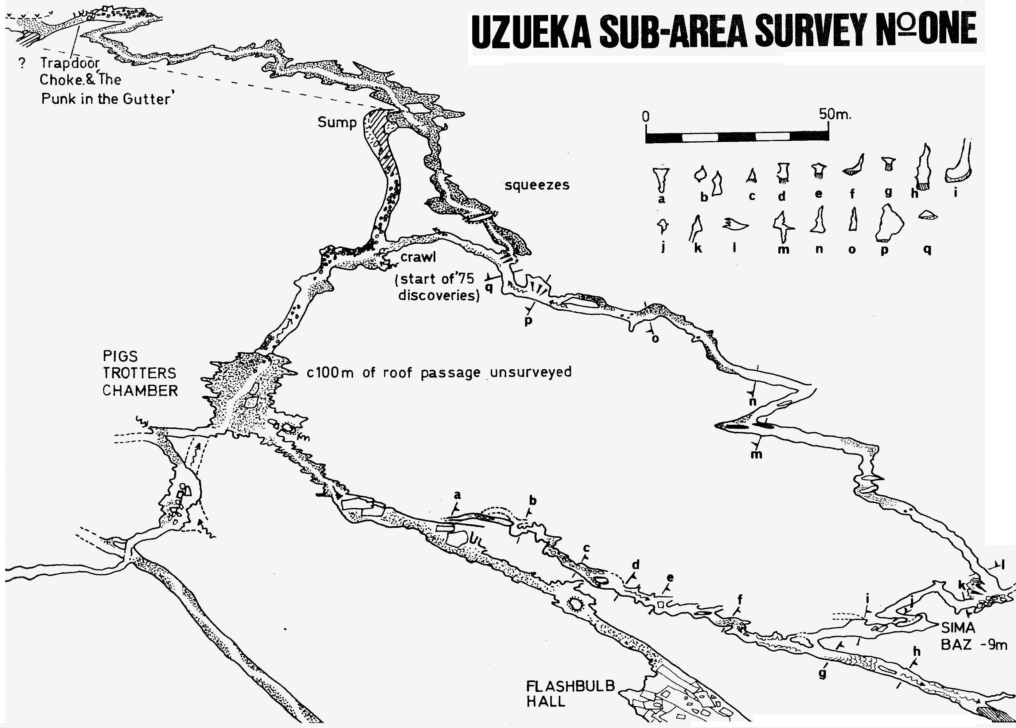
Flashbulb Hall is a shattered, damp area of massive block collapse. On the righthand wall of FBH a small inlet passage remians unexplored. The main way on is a roomy passage leaving FBH opposite the point of entry. Several holes in the floor are passed and there is a possible roof passage at the point of entry. Attempts were made to reach this at Easter 2010 but bolts are required to complete the route. The main way reaches a large block where a 16m pitch enters the maze area around Pull-up Passage. To the right, traversing across deep holes (traverse line advisable) leads to an aven and shaft where pitches of 6m and 16m pitches, descended in 2009, connect to the maze around Pull-up Passage. Crawling on a ledge around the shaft leads to ongoing large passage (Vampire Gallery) and a low level streamway. The large passage chokes. At the choke a climb up leads to a short section of passage (surveyed Easter 2010, but previously entered). A low streamway on the left of the choke is too tight upstream and has not been explored downstream. An inlet on the right before the choke has been surveyed to a stal squeeze, continuing beyond. Back at the traverse at the large block, a route to the left enters a chamber where a climb up a fissure on the right enters Dog Series (see below) - large, well-decorated passages. Bones seen in 2009 seem to be close to a former entrance.
In the Dog Series, a traverse over the top of the climb up was made in 2009 - 2010 entering large, sandy passage rapidly degenerated to a low crawl. On the right before the crawl a passage was explored to a short pitch into a chamber. This ended at an over tight tube and, under the pitch, a too low streamway.
A description of the Dog Series Resurvey (that carries on from the first section survey) dated 30/3/2010 follows: Slippery slope down to a 20 aven with big holes on the left of the passage. Straight ahead a climb up a boulder and down leads to a passage on the left (see below). Some stal on the left wall, reminiscent of Agincourt. The passage opens up to the right with a slope up to the Dog's Bollockson the far wall. Heading right from here there is a calcite slope to the left of the passage which ends at a calcited choke, then carries on over flowstone with stal and gour pools on a large calcite boss. This wide passage slopes up to the left with an oxbow high up on the right hand side. Climbing up the calcite slope on the left, around some stal, the passage divides in two with a left hand fork continuing low among stal. A rock arch on the right of this leads to a 9.2m aven with tree roots. There is a two metre, small drop to the right of this aven which is choked. The right hand fork is a sandy crawl, passing some "cauliflower" formations, to some gour pools and passages to the left and right which both close down.
Heading back to the Dog's Bollocks, the main passage continues very large and into a maze area. The passage to the right is an oxbow.
By continuing upstream at the first wet crawl, walking sized passage is reached. The stream is left where it emerges from a low section and a higher level phreatic tube entered. Awkward progress is stopped by the 9m Sima Baz. A short length of passage enters an immature stream that sumps 50m downstream and becomes too tight 100m upstream.
Summer 2010 also saw extensions in the above area. The tent pole climb was completed in Flash Bulb Hall but the passage was found to choke immediately. The "next hole in floor of passage after dog-leg after Flash Bulb Hall" was descended for approximately 5m only to find an over-tight fissure at the base. In the high level chamber between Flash Bulb Hall and Pigs Trotters was investigated in left and right hand pitches. The God Knows Series was resurveyed and slippery climbs at the end leads to the foot of the left hand pitch above. Goldie's Way was also surveyed for about 210m of meandering canyon in this area. A route down to the streamway met upstream and downstream sumps and carbide, suggesting the Sima Baz passage. (Proper write-up required.)
At Easter 2012, the mystery of the Sima Baz streamway was rectified when resurveying and new exploration showed the streamway had originally been drawn up 180 degrees out. The Real Sima Baz streamway heads west-southwest upstream to where the passage splits and water can be heard ahead through a low section. Part way along a strongly draughting passage heads off to the northeast to enter Tom's Antic, up a c4 after a wallow through waist-deep mud. To the right this ends in narrowing rifts which come close to the end of Goldie's Way. Full description needed:
Extensions in Gorilla Walk?
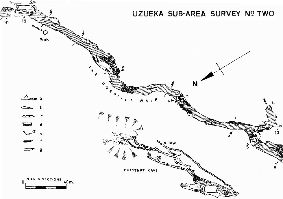
At Easter 2002, two extensions were pushed around the Gorilla Walk. The first
is found on the right of the passage before dropping into the water. A draughting
dig through boulders to a 4m climb up. The passage trends upwards passing
over the Gorilla Walk and ending up about 30m above water level and 70m west
of the starting point.
The second extension is Windy Inlet a strongly draughting inlet in
the roof about 3/4 the way along the Gorilla Walk. The passage is
generally small to a 6m climb. Beyond is a rift excavated of boulders that
leads to an aven that has been climbed to where the passage appears to finish
close to site 253 and site 2691.
This Windy Inlet series is described as requiring SRT kit for 5m and
30m climbs.
Over Easter 2007, the top of the 30m aven was molephoned and positioned under
a large depression close to site 253 and 130m east of Cueva
de las Castañas. The molephone position in the depression (about
7m above the underground station) is documented as site
2691. At Easter 2008, the Giant Panda entrance (site
2691) was dug out and cavers emerged from Hoyuca after climbing up from
the Gorilla Walk. The new, top entrance has been partially stabilized
using acros and planks and the route in and out proved a couple of times.
A new survey has been carried out from top to bottom. (See
site 2691 for Giant Panda description).
Green Van Series, etc?
A dye test from Cueva de las Castañas (102) has been carried out and fluoroscein emerged between floor pebbles in Gorilla Walk opposite the entry of the last downstream inlet (on the left), but no dye was seen in the inlet water!
The Zoological Gardens leads off from the phreatic passages at the end of the Gorilla Walk as a wide, muddy crawl. The passage continues as a rocky rift with some very impressive fossil corals in the floor. There is one calcite formation or fossil which looks like the vertebrae of an animal about 30cm long. The passage ends at a calcite blockage and was surveyed for 265m in 1997.
Second River Inlet is 200m of mixed caving ending at a low crawl with a powerful draught. The link through into Cueva de Riaño (105) was made with the minimum of digging in 1986, and the first through trip - Hoyuca maize field entrance to Riaño entrance - at Easter 2008. This inlet is awkward in places, having three tight sections near the Riaño end. The first is a squeeze between a solid limestone roof slab and flakes on the floor, followed by two flat out tight squeezes in the stream which may have to be re-excavated of gravel to pass.
The next feeder is Gour Inlet, easily recognized by the cream colored
flowstone on the stream bed where it emerges into the main river passage.
The initial crawl is in an oxbow to the main passage and the inlet joins
part way round. This starts flat out in water but quickly gains height. The
passage has been described as "a really lovely inlet with nice walking
and formations". This ends after 150m at a bouldery, 35m+ high (disto
measurement) chamber and a climb which was bolted up an overhanging crack
on the right wall in 1993. The top and the observed large passage (with stal
bosses and lots of mud) was not reached due to shattered rock on the chosen
route. In the summer of 2006 a quick trip before an aeroplane flight gained
a new perspective. A new bolting route was started on the opposite wall in
a corner that looked easier than the previous route. At +5m a traverse is
stopped because of sandstone. By going back to the right a little a climb
over calcite regains limestone at about +12m and easy bolting. From this
new vantage point the passage does not exist but there may be a continuation
above the inlet back towards the main passage. The chamber also continues
up for at least another 30m
The inlet water comes from boulders at floor level and it may be worthwhile
to dig at this choke.
At Easter 2008, Gour Inlet was pushed for 369m heading east. A climb up has
now been laddered and a traverse along a ledge enters a passage several metres
up the back wall which had been previously entered. The way on is via a slot
hidden in the wall behind a flake. This had clearly not been entered before,
as the mud floor was untouched, shiny, sticky mud. This passage can be followed
through muddy, crawling passages to an 8m pitch down into a streamway.
The pitch is a straight hang of around 8m into a widening rift. Landing in
a thigh deep pool, the stream enters down a 2m cascade which is covered in
the same cream coloured flowstone which is found all along Gour Inlet.
Downstream, the passage sumps round the first corner, but upstream leads
into a big hading rift where a long climb up a precipitous slope comes to
a point below a large boulder choke. Climbs up into the boulders look possible
but precarious, and a lot of rubble has obviously come down into the chamber
from this choke in the past. Continuing upstream at the base of this chamber,
the stream soon sumps again, but an obvious dry oxbow provides a bypass and
the stream is regained. Further crawling on cream coloured flowstone in the
stream leads to another sump, with another dry oxbow. But this time the oxbow
lead into a boulder choke.
An excavated route through this boulder choke soon leads into a large chamber
with a damp sandy floor which can be climbed up to a summit in the middle
of the room. The chamber is named the Soggy Sahara. From the middle
of the chamber the stream can be heard louder than ever, and is found entering
the chamber down a 3m cascade at the far side and sinking into the floor.
Upstream from here requires some careful traversing over a deep pool with
a low ceiling before the passage opens up into a tall walking rift passage.
Passing some fine lone straws hanging right in the middle of the passage,
a long straight section leads to a right angle bend and more taller walking
rift. A loud rumble can be heard in the distance and the source is eventually
reached, a 6m diameter circular chamber with water raining down from above
into a deep pool. The rift just before this point is over 10m high, and the
aven itself was impossible to measure on the original exploration due to
the spray from above. The water was coming down all over the place, so either
it was broken by a ledge as it fell, or it was coming from more than one
passage above. It may be that a substantial amount of it emerges as a spout
about 15m up, but it was too wet to be sure of anything. At the end of the
original exploration and survey trip, the final sketch was finished with
water pouring across the page. The team retreated from the spray, wind and
noise to start heading out, thinking that the most appropriate name for this
pitch at the "end" was Sensory Deprivation. The logbook account of
the trips to push Gour Inlet at Easter 2008 can be found
here.
[Interim description] During the summer 2008 explorations a dry, 25m high
aven greeted the explorers and the chamber was renamed The Thunderdome.
The first rash of bolts meet a slope to a large passage heading west. This
was pushed to the top of the original aven in "old" Gour Inlet and, with
various loops and side routes, the total length of this segment comes to
816m. Also along this passage are fine fossils including corals and a set
of vertically stacked fault chambers, where huge blocks have dropped off
sandstone beds to create a 30m high series of voids. The water inlet is reached
by a bolt route and a streamway entered. Over 550m is surveyed on a NE trend
in walking passage about 2m wide and up to 20+m high. The passage continues
for an estimated 350m past grottos and up a set of half metre cascades where
it changes to a hands-and-knees crawl. The water emerges from a choke of
large, rounded cobbles. The whole of this streamway is on a very shallow
gradient with a cream flowstone floor. There is knee deep wading in the upstream
section. The series was "completed" and surveyed at Easter 2009.
On a trip in the summer, 2010, Gour Inlet was investigated along its length from the Thunderdome to find any higher level inlets or routes. A big phreatic tube (up to 10m wide) can be followed at roof level with hairy steps over the canyon below. There are "lovely white and beige banded rock layers, swirl pockets and domes" in the passage, about 15m above the streamway. The route can be followed (with no side passages going any distance) to near the upstream choke where the old, mature passage leaves the younger stream. This has been surveyed upwards in a big aven / rift with large boulders filling it. A solid fluted vertical wall all the way up through the boulders appears to indicate a large wet shaft in the past. Large amounts of pure white flowstone and beautiful helictite-encrusted stals are found in the top. A possible way on couold exist further up in the roof but there is no way the calcited aven could be bolted. An air flow is felt in this area. A phreatic maze can be explored further back downstream and roof tubes have been pushed into a grotto with pristine white stal but no continuation.
By continuing downstream at Obvious Junction, Far Stomps is entered. This large passage runs for 550m over giant blocks to a sump - the water passing through to Sandy Junction. Near the start of this passage, a small inlet runs for 40m on the south side until it becomes too small where a false floor divides the passage.
Third River enters at the end of Crossover Crawl and is 800m of fairly unpleasant passage. After 200m upstream, a deep pool has to be negotiated followed by 300m of crawling and rift passage to where the water emerges from a sump. This point is about 50m from the downstream sump in Torcón de Riaño (106) although a human connection is unlikely. The rest of this uninspiring section of cave lies up on the right and ends at a couple of avens apparently over the top of the crawl traversed before.
Straw Inlet starts as walking passage but degenerates into a low crawl over mud. A passage near here was pushed during 1995 and ed the following year. The route draughts in well but goes up into a very slippery calcited boulder choke. Forging a way on would involve bolting and a major push.
Sloppy Inlet starts as a crawl in water from a pool under the left wall and soon reaches a series of climbs to an impressive aven (photos here). The main explorations were in the summer 2011 over 2 trips (survey batch 0107-11-10). The accounts can be read here. The "end"- at the 7 x 5 x 48m - Tixtu Aven, with water coming down the centre, was bolted up over two trips in August 2014. In December 2016, the "tatty rope on the big pitches" was changed for a "nice new 11m one". On the same trip, two short pitches that drop into the passage off Diversion Chamber were rigged to avoid a Sloppy Inlet soaking.
Tixtu Aven Twenty eight metres up is a ledge with a small, muddy rift passage that ends at a tight, unexplored pitch down. A bolted, airy traverse around to the south reaches a sloping ledge with the aven continuing to soar upwards to an inpenetrable(?) slot in the middle of the ceiling where the water emerges. The hole appears to be in sandstone at the same altitude as the top of the Astradome. The ledge slopes up to another, not quite as tight, muddy streamway with crumbling mud walls which goes for 30m to a 28m pitch down, 3m across at the top. This drops into Professional Advice Chamber with hanging boulders as a roof and lots of holes between big boulders on the floor.
Turning right in this chamber, a large passage is entered and a ledge on the left leads past a circular pot and along into a dead end after 20m or so. In this dead end is the skeleton of a mammal, big enough to be a bear, wolf or wild boar, "but could be anything!" (Video on You Tube) The remains were identified in 2019 by palaeontologist Pedro Castaños as leopard, Panthera pardus. Some of the teeth brought out for identification have been coded as 107-19-1, 2, 3, 5, 6 and 7 in the Catalogue of recent finds of teeth and bones in MCP caves / digs (2018-2019 ). (Peter Smith)
In the summer 2019, after taking more photos of the leopard bones, a conical pile of sand was noticed next to the skeleton then a climb up a hole leading to a series of breakdown chambers with scary false floors and loose boulders. A skeleton of a small rodent was seen and the extension surveyed to 63m in length (batch 19-01 and incorporated into the Hoyuca survey as sloppyinlet.part5_2019)
A 1m circular pothole just back from the leopard gives a 12m pitch into a lower passage doubling back to below the Professional Advice Chamber with a 3m free climb into this lower chamber, the roof of which is composed of the boulders we were stood on previously. A short crawl at the far end of the lower chamber gives access to a further chamber and a large 3 to 4m diameter passage heading off to the right. After 15m it degenerates into a very narrow streamway. This can be forced this downstream for around 30m to a small aven where the survey batch 0107-14-02 ends. The aven closes down. Downstream reaches a similar aven and, past this, a wider (1m), taller (4m) rift passage with some boulder obstacles.
The rift passage was pushed in January 2019 for another 40m and the area surveyed as batch 0107-18-01 (SloppyInlet/Part4-2018). (View plan and section jpegs from the .top file). ( A video on YouTube after the Christmas 2018 explorations can be seen here.)
A couple of bolt climbs were carried out around the current top of Tixtu in August 2019. Nothing was found that warranted surveying, although a sketch of the explorations was made in the logbook and a video (on YouTube) made. The route: bolt climb over the drooping "king horn" protrusion - about 7m - to a window that drops down 7m to a ledge with a deep pool. Aslot through, just beyond the poolleads to further fluting. A bolt climb over the next fluting leads to a drop down onto a blind ledge. [After Diane Arthurs summer 2019 logbook description.]
Diversion Chamber Inlet description? Surveyed Easter 2012. Other new sections from Easter 2012 to be described.
Fourth River Inlet ends at a draughting boulder choke after about 200m. This was pushed past the choke in 2010. A straightforward crawl along the right hand side enters about 100m of small stream passage, ending at a squeeze.Most water enters from the roof shortly before the end and the whole series appears very immature and rather unpromising. The choke may be concealing a larger passage but appears to be rather unpleasant in places. A seacond trip apparently explored further and carried out a survey.
Eighty metres downstream from this point the entrance to the Astradome is seen on the left hand wall. A short walk up and along a muddy floored passage breaks out into a magnificent circular aven. Single voices sound like cathedral choirs as they rebound off the walls of this 30m diameter and 102.5m high feature. An interactive view around the Astradome can be seen here.
In the summer of 1993 the Astradome was bolted up in about 10 hours over 2 days. The climb was stopped about 4m from the top by a bed of sandstone which would not take the studs. A hole in the roof was visible. In 1994, the climb was completed using a scaling pole. A chamber above was entered with passage above. It was from near the top of the Astradome that Alan Box fell to his death in that year. The passage 8m up was scaled into in 1995, but choked along the fault line in both directions. The climb was rigged from the base as 31.3m, 26.5m, 23.9m, 11.3m, 9.5m - that is 102.5m from the base to the lip.
95 Inlet can be entered on the right of the main river just after passing through 44 Chamber. Fifty metres in, an elliptical tube in the roof can be entered which leads to an increasingly muddy section of phreatic cave. The area appears flood-prone as a sump is bypassed via a muddy tube. The passage then slowly ascends to a 5m climb up to the boulders half way along Armageddon. This partial Armageddon Bypass is 500m long.
A small inlet on the right of Paisley Passage has been pushed for 250m to a large aven, Indomba. The route was re-explored (and further pushed?) in January 2024 through avens of 45m & 37m to end(?) at an impressive, very large, circular Indomba aven, with a custard-coloured flat floor where the disto would only read a maximum of 62m up due to the spray from falling water. However, it looked much higher than this as a powerful 3000lm aven blasting torch couldn't illuminate it to the top!
The final "small" inlet of note is Shrimp Bone Inlet
- the upstream continuation of the vadose rift passage that joins
Duckhams Sump to Rocky Horror. The passage was explored for
some 700m in the initial pushes. During Christmas 1989 the end was pushed
for another 517m to a small, climbable aven. The end apparently lies under
Sima del Escajadillo (088) although no sign of this
(Spanish explored) pot can be found on the surface. During the Easter 2000
expedition, the aven was climbed for some 15m to a blockage with an inlet
stream passage beyond. A subsequent trip removed the blockage and explored
a further 300m.
The slot at the top of the pitch opens out almost immediately to an elongated,
well decorated, oval chamber. Above and behind the slot at the top of the
initial pitch the massive calcited boulder pile continues on up with several
black spaces visible for 15m or so. Climbs up into this were too steep and
slippery to consider with the gear available. At the opposite end, a 3m waterfall
comes down off the edge of a 2m deep false floor only a couple of inches
thick at it's outer edge. There is now a ladder hanging down this, initially
awkward, obstacle.
The passage above is a slightly smaller version of Shrimpbone Inlet, being
generally a joint controlled rift 1.5m - 2m high though in places the stream
meanders turn this into a low tube / bedding. After 50m or so cross rifts
are met which generally go a few metres to small avens (10 - 15m high?).
There are some nice long straws in places. After approximately 150m a junction
is met with a tall rift going right and left. Left, goes to a climb up and
a tall aven. Right, goes through a calcited slot into a chamber at the base
of several large dripping avens (20 - 30m maybe more), named Mongooses
Don't Jump. The stream is not evident in this aven area, though whether
it comes from water percolating through the sand and rocks at the base of
the avens or from elsewhere is not clear. The last survey station in the
terminal chamber is marked with a plastic novelty ice cream container.
***NOTE*** The next team in should take a sturdy new rope and possibly some
climbing / rigging gear as the climbing rope may not last another party going
up and down it.
An account of the second, 15 hour, trip to the end of Shrimp Bone Inlet is found here (Easter 2000) and a BEC report in the Belfry Bulletin, here.
Exploration of some side passages in Shrimp Bone Inlet occurred at Easter 2023, after Torca de la Decepción was linked in the year before. These are:
Batch 0107-23-02 Tantrum 66m. (Drawing) A narrow passage that links back. (Photo)
Batch 0107-23-03 WOA 16m (Drawing) Small sandy passage with tight squeeze into 5m low continuation.
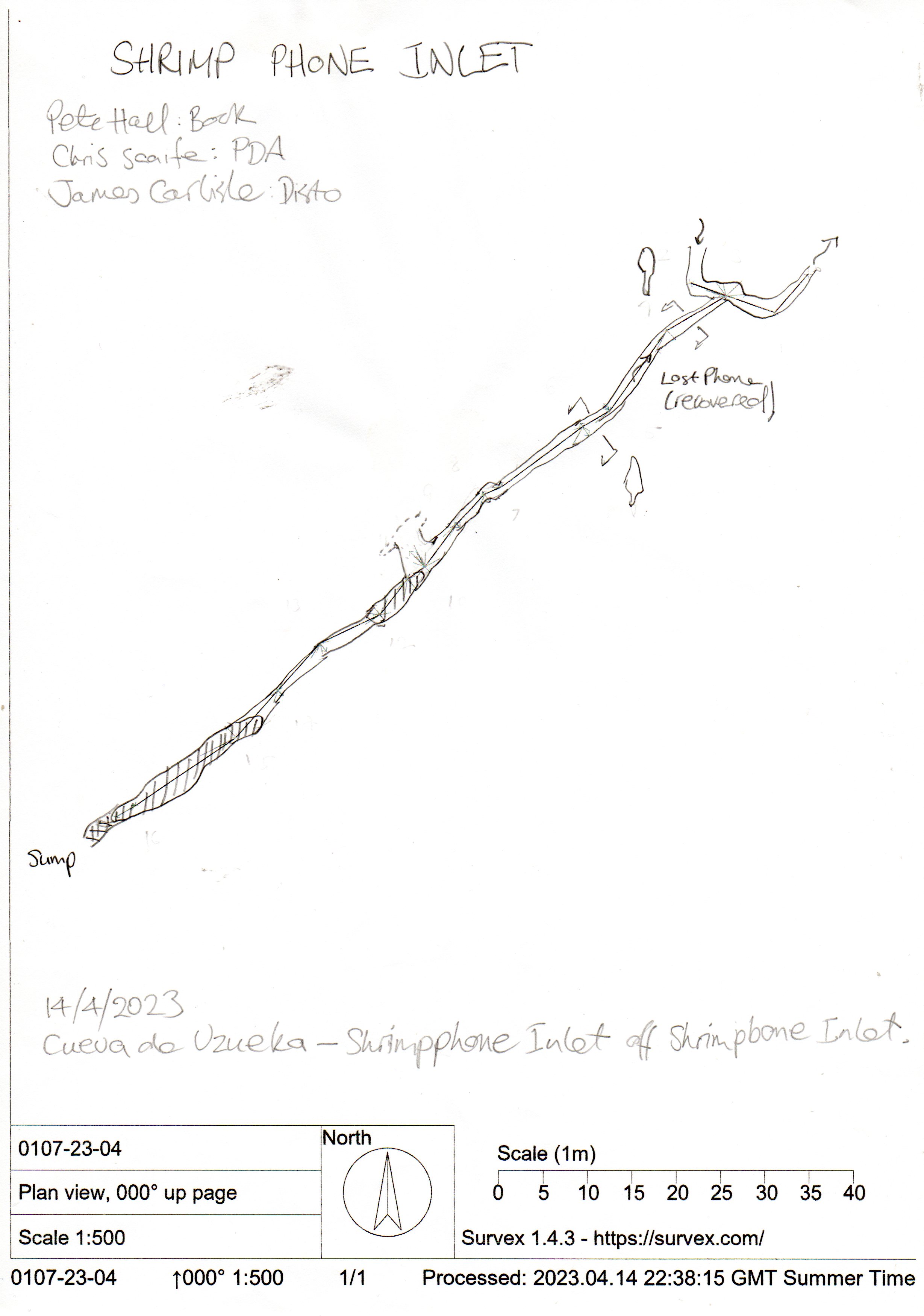
Batch 0107-23-04 Shrimp Phone Inlet 92m (Drawing) A narrow passage where a phone was dropped down a rift, and later recovered. (Account here). The passage passes through a canal and a duck to end at a final sump. (Photos)
Trident Passages, the major set of "side passages", have a length of 3.2km (? Jan 2024) and are entered by climbing
up calcite on the right after leaving the inlet at the start of Rocky
Horror. At almost the highest point reached a clamber down over boulders
to the right reaches a 31m diameter, smooth floored chamber. One outlet descends
too tightly, but the main route is a squeeze and clamber then walking to Mace Head
Passage, of stooping dimensions and one of the better looking passages
in Cueva de la Hoyuca. Large spiky crystals and calcite formations decorate
the 1m diameter tube. Gates to Trident? Then the passage splits...........? More description
needed.
(All the early logbook entries for Trident Passages are brought together here.)
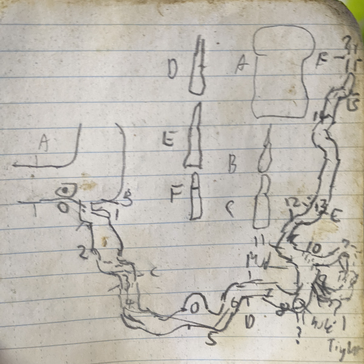
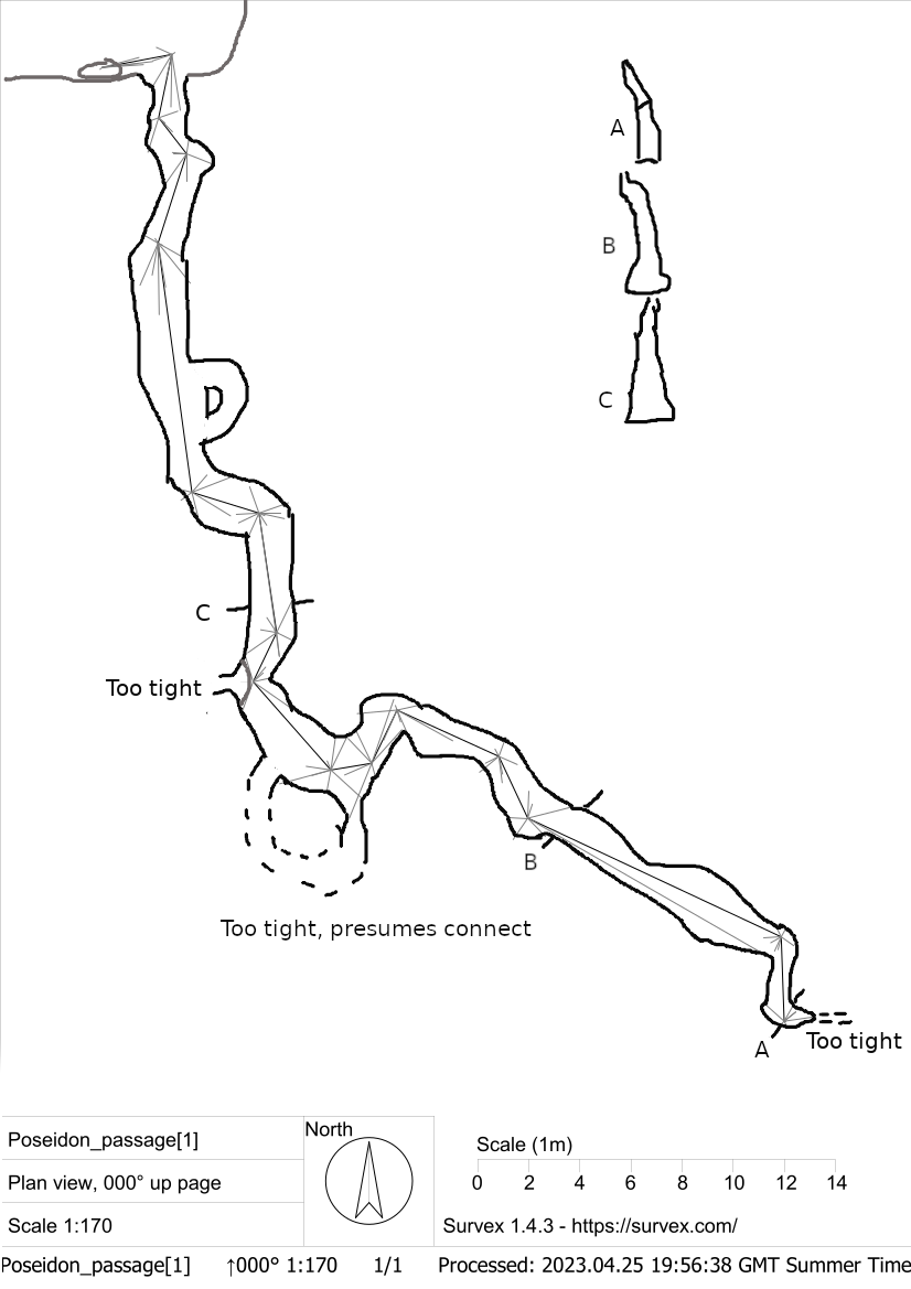
After Torca de la Decepción (0252 / 4732) was linked in at Armageddon and Shrimp Bone Inlet (summer 2022), work started re-exploring the Trident Passages and Shrimp Bone Inlet (see above). A short extension in Trident is shown as batch 0107-23-01 (with scanned notes on file and sketch), Poseidon Adventure, where 60m of small passage ends at a "wall of mud". Some phone video was also shot during this visit.
A survey by Chris Scaife from station 68 on the old survey needs adding. (summer 2023)
Summer 2023 saw further (re)explorations and a re-survey from Armageddon through Duckham's Sump up to Trident Passages, including a foray up into the Gypsum Traverse which was positioned correctly on the survey. The resurvey is now shown on the 2023s centre lines below.
Timings from Casa Germán to Trident:
For two moderately ladened cavers not sightseeing on the way:
Bar Germán to entrance: 40 mins
Entrance to bottom of Grand Slam: 40 mins
Bottom of GS to 'camp 1': 60 mins
Camp 1 to Sandstone passage/LH passage junction: 15 mins
And the same for the return journey.
So around 5 ish hours minimum for a round trip, for two moving fairly quickly and not really stopping. [Simon Cornhill, Diane Arthurs]
Extensive explorations around the Christmas period 2023
were made in the Trident Passages. The following description has been gleaned from the logbook accounts by Diane Arthurs and Simon Cornhill of the exploration trips.
There is a wet, muddy squeeze (The Gates to Trident) below the climb up into the Gypsum Traverse which has been excavated and is much more pleasant. The bolt climb up over the calcite blockage has been rerigged to give a free hang on the up and down pitches. A route along the bottom of the trench leads to a final calcited chamber. Part way along the trench, a climb up reaches a higher level passage which meets the entry point along a traverse line up into the higher level.
To the SW of the climb up into Gypsum Traverse the passage leads to the knotted rope climb on the main route. The traverse involves two exciting rock-climbing style pitches along steep, sketchy terrain. From the top of the knotted rope climb, the passage continues to the junction with Sandstone Passage and Snow White. A climb up into the stunning Snow White was surveyed along the main passage and then along an un-surveyed smaller but amazing walking gypsum encrusted passage which eventually rejoins the main route after a climb up from the trench in the floor.
The Left Hand Passage / Snow White, has been thoroughly checked for any leads including climbs into numerous cross rifts and alcoves, which all close up. This area is a hading rift which is also very heavily calcited, particularly at the end. Some side passages marked as 'to chamber' on the old survey turned out to be a view into the large junction of Sandstone Passage and Snow White from a high vantage point.
The final bolt climb in Snow White is at the highest point in this area into the largest cross-rift which also became too tight. The altitude is around the height of the survey station set at the top of the Astradome, and makes it one of the highest places in Hoyuca.
A WhatsApp chat about passages in Rocky Horror / Trident is included in the 2024 January / February logbook.
Depths below the Matienzo hillside. Molephoning.
At Easter 95, Pull Up Passage was entered off Quadraphenia and was surveyed for 123m to a sump and narrow rifts. The rotten ladder was removed in April 2022 although the rope remains in place.
During summer 2000, Wildlife Series was discovered through a hole
at floor level at the start of Quadraphenia, 10m north of the tight
squeeze. A crawl leads onto a 6m pitch into a streamway. Downstream, the
passage becomes too low. Upstream, the passage splits with all branches choking
except for one which turns west and links back to the chamber at the entrance.
The passages are mainly stooping or crawling and were surveyed for 320m.
In September 2012, a blue harvestman (Gyas titanus) was photographed in the entrance series of the cave and the Astradome appeared as the front cover of Descent 229 at the end of the year thanks to Paul "Footleg" Fretwell.
Link to entry in the Cave Diving Sump Index.
References: anon., 1974b (logbook); anon., 1974a; Fernández Gutiérrez J C, 1975; anon., 1975b (Easter and summer logbooks); Kendal Caving Club and Manchester University Speleological Society, 1975 (survey and photo); anon., 1976 (logbook); Cope J et al, 1976 (survey); anon., 1977a; anon., 1977b (logbook); anon., 1978 (logbook); Corrin J et al, 1978 (survey and photo); anon., 1979 (logbook); Addis F et al, 1979; anon., 1980a (logbook); Corrin J et al, 1981b (survey and photo); Corrin J, 1980; Mills L D J, 1981; Manchester University Speleological Society, 1982 (survey and photo); Mills L D J and Waltham A C, 1981 (survey); Corrin J S and Smith P, 1981; anon., 1981a (logbook); Corrin J et al, 1981a; Corrin J, 1981; anon., 1982 (logbook); Smith P, 1982b; Corrin J, 1983c; anon., 1983b (logbook); Cawthorne B, 1984; Corrin J, 1983b (survey); anon., 1984 (logbook); Barrington P and Hanson D, 1984; anon., 1985b (logbook); anon., 1986 (logbook); Corrin J, 1987 (survey); material in file; anon., 1987 (logbook); Garcia J L, 1987; Corrin J and Knights S, 1988; anon., 1988 (logbook); Davis J and Corrin J, 1989; anon., 1989 (logbook); Smart C, 1990; anon., 1990b (logbook); anon., 1990c (logbook Whit); anon., 1991 (logbook); Corrin J, 1992a (survey); Corrin J, 1992b (survey); Corrin J and Quin A, 1992 (survey); Corrin J, 1993 (survey); anon., 1993b (logbook); Quin A, 1993a; Smith P, 1993 (survey); Corrin J, 1994a; Allen T et al, 1994; Corrin Juan, 1995b; anon., 1994a (Easter logbook); anon., 1994b (logbook); Neill A, 1994; Corrin J, 1994b (survey and photo); anon., 1995a (Easter logbook); anon., 1995c (logbook); Corrin Juan, 1995a; anon., 1996b (logbook); Corrin Juan, 1997a; Corrin Juan, 1997b; anon., 1997a (Easter logbook); anon., 1997b (logbook); Corrin Juan, 1998; Fernández Ortega F, Valls Uriol and Maria del Carmen, 1998 (photo); García José León, 1997 (survey and photo); Corrin Juan, 1997c; anon., 1999c (logbook); anon., 2000b (Easter logbook); anon., 2000c (Summer logbook); Corrin Juan, 2001 (photos); anon., 2001c (Summer logbook); Corrin Juan, 2001a; anon., 2002a (Easter logbook); card for Aug 2002 Roof Passage survey; Corrin Juan, 2003a; Corrin Juan, 2003b; Corrin Juan, 2003c; anon, 2006d (summer logbook); anon., 2007b (Easter logbook); anon., 2007d (summer logbook); Corrin Juan and Smith Peter, 2007;; Corrin Juan, 2007a; anon., 2008c (Easter logbook); anon., 2008d (Whit logbook); anon., 2008e (summer logbook); Corrin Juan, 2009; anon., 2009a (Easter logbook); anon., 2009c (summer logbook); Corrin Juan, 2010; anon., 2010b (Easter logbook); anon., 2010c (summer logbook); León García José, 2010 (Volume 1 and Volume 2) (line survey and photos); Corrin Juan, 2011 (photo); anon., 2011b (Easter 2011); anon., 2011d (summer logbook); anon., 2011e (autumn logbook); anon., 2012a (January, February logbook); anon., 2012b (Easter logbook); Fretwell Paul, 2012a; Fretwell Paul, 2012b; anon., 2012d (summer logbook); Corrin Juan, 2013a; anon., 2013b (Easter logbook); anon., 2013d (summer logbook); anon., 2014b (Easter logbook); anon., 2014c (summer logbook); anon., 2014d (autumn logbook); anon., 2015b (Easter logbook); anon., 2015d (autumn logbook); anon., 2016b (Easter logbook); anon., 2016e (Christmas logbook); anon., anon., 2018e (Christmas logbook); anon., 2019b (Easter logbook); anon., 2019d (summer logbook); Scaife C, 2022; anon., 2022b (Easter logbook); anon., 2022c (summer logbook); anon., 2023b (Easter logbook); anon., 2023c (summer logbook); anon., 2023e (Christmas logbook); anon., 2024a (January, February logbook)
Trident Passages: Logbook entries 1981 - 1991 (produced July 2023)
Entrance pictures : yes : The Dairy Museum at the field entrance
Underground pictures: Quadraphenia 1 2 : Small phreatic tube : Quadraphenia squeeze : Pig's Trotters Chamber : Pitch towards Flash Bulb Hall
Scanned slides in the entrance series through to the Astradome by Frank Addis, 1978
Scanned slides in Las Playas to Rocky Horror by Frank Addis, 1980
Scanned slides of bolting the Astradome, 1993
Digital photographs in Wild Life Series by Juan Corrin, 2000
Digital photographs in the entrance series by Juan Corrin, 2001
Digital photographs in Gour Inlet Extension by Mandy Fu, 2008
Digital photographs in Quadraphenia by Peter Eagan, 2008
Digital photographs in Gour Inlet Extension by Paul Fretwell, Easter 2009
Digital photographs from entrance 2 at the base of the maize field to the Far Stomps area, summer 2009.
Digital photographs from in and around the Dog Series, Easter 2010.
Digital photographs from in and around the main stream, the Astradome, Dog Series and Gour Inlet, summer 2010.
Digital photographs from explorations over Easter 2011.
Digital photographs from explorations over summer 2011 (Sloppy Inlet).
Digital photographs from September 2012 visit to the entrance series. Blue harvestman.
Digital photographs from summer 2014. Astradome.
Digital photographs from Easter 2016 - around Flashbulb Hall.
Digital photographs from December 2016 - Diversion Chamber & Astradome.
Digital photographs from December 2018 - leopard skeleton and teeth beyond Txitu Aven / Professional Advice Chamber
Digital photographs from August 2019 - the entrance series of Cueva Hoyuca
Digital photos from August 2019 - Tixtu Aven; Leopard & possible rodent bones
Digital photos from Summer 2022: Photos were taken as Torca la Decepción was linked into Armageddon and Shrimp Bone Inlet / Rocky Horror.
Digital photos Easter 2023: Rocky Horror / Trident Passages : Shrimp Phone Inlet and Tantrum Passage
Digital photos summer 2023: Trident Passages (Chris Scaife) : Big stick and Rocky Horror (Dave Barrett and Alex Ritchie) : Armageddon to Rocky Horror and into Trident Passages (Diane Arthurs and Simon Cornhill)
Digital photos Xmas period 2023, all taken by Diane Arthurs and Simon Cornhill : Paisley Passage and Inlet : Gypsum Traverse (18th, 21st, 24th December, 2023) : Macehead Passage (30th December, 2023) : Snow White and the Left Hand Passage : misc - Trident start; gypsum formations; side passage
Interactive VR of the Astradome by Paul Fretwell, 2011
Spanish blog of trip to Astradome (May 2011): nice photos
Spanish blog (Oct 2010) : Spanish blog (March 2012)
Videos: See videos list
Detailed Surveys :
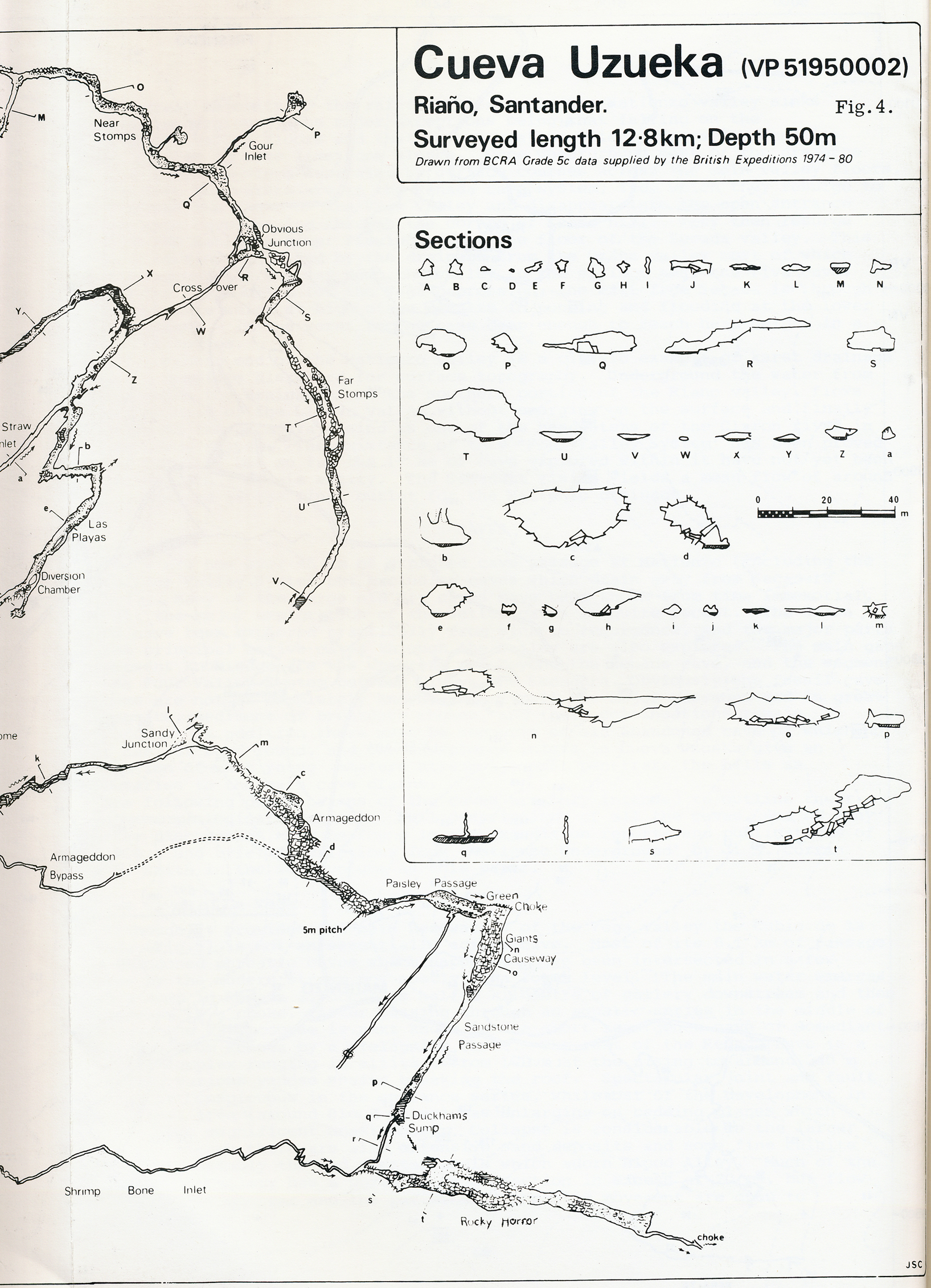
| 1974 | original survey | high res | |
| 1975 | known cave | low res | high res |
| from rescue site | 1975 passages | low res | high res |
| 1975 | Pigs' Trotters & Flashbulb Hall areas (Sub area 1) | low res | high res |
| 1975 | Gorilla Walk & Chestnut Cave area (Sub area 2) | low res | high res |
| 1976 | Reincarnation (Armageddon to Rocky Horror) | low res | high res |
| 1980 | known cave survey from BCRA Transactions | low res | high res |
| 1980 | as above in sections ... left half | low res | high res |
| 1980 | as above in sections ... right half | low res | high res |
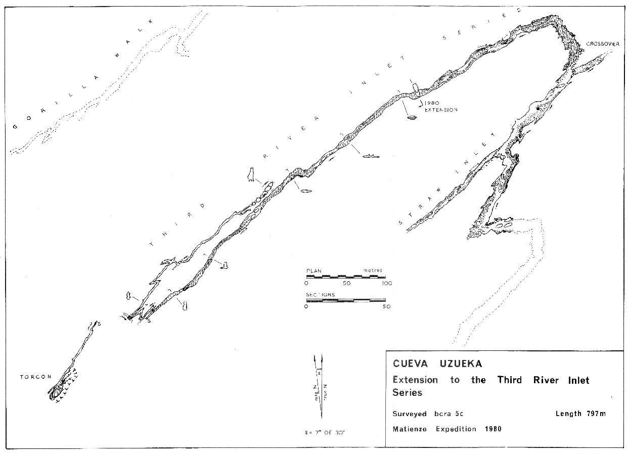
| 1980 | Third River Inlet with Torcón | low res | high res |
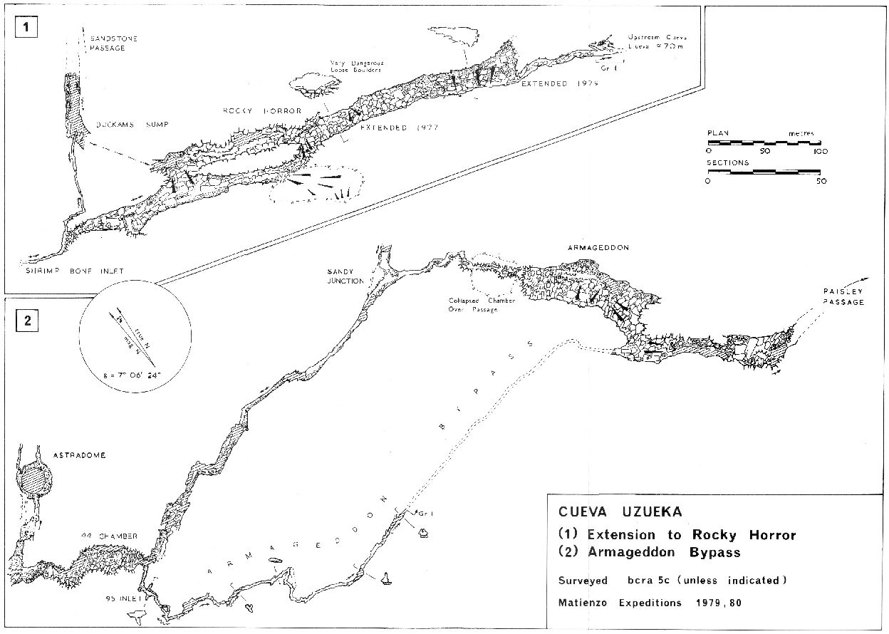
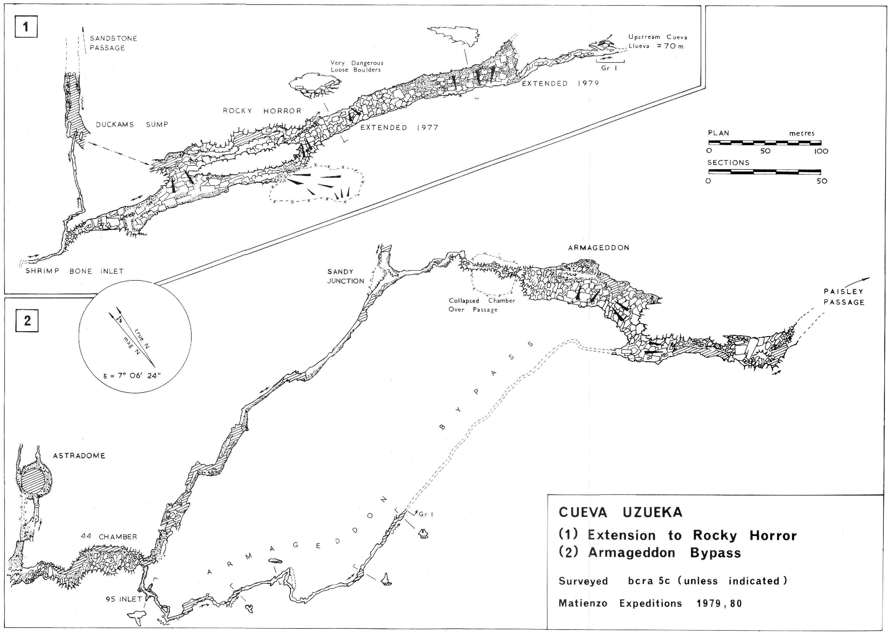
| 1980 | Rocky Horror & Armageddon Bypass | low res | high res |
Detailed Surveys : 21st Century resurvey
| 2008 24th Jan | Hoyuca entrance & Riaño | B&W png file |
| 2008 24th Jan | Hoyuca entrance & Riaño | colour png file |
| 2009 Easter | Hoyuca entrance passages | colour png file |
| 2009 Easter | Hoyuca entrance & Riaño | colour png file |
| 2010 Easter | Hoyuca entrance passages | colour png file |
| 2010 Easter | Hoyuca entrance & Riaño | colour png file |
| 2011 Easter | Hoyuca entrance | colour png file + notes |
| 2011 Autumn | Hoyuca entrance & Riaño | colour pdf file + notes |
| 2019 summer | Tixtu Aven plan sketch | sketch |
| 2023 Xmas | Trident Passages | pdf file |