Updated 30th August 1998; 19th February 1999; 14th May 2000; 26th July 2000; 1st April, 6th May, 10th June, 7th October 2001; 8th April, 24th October 2002; 13th October, 8th November 2003; 1st February 2006; 26th September 2008; 6th January 2011; 14th May 2014; 9th September 2015; 30th June 2018; 3rd March 2022; 8th May 2023
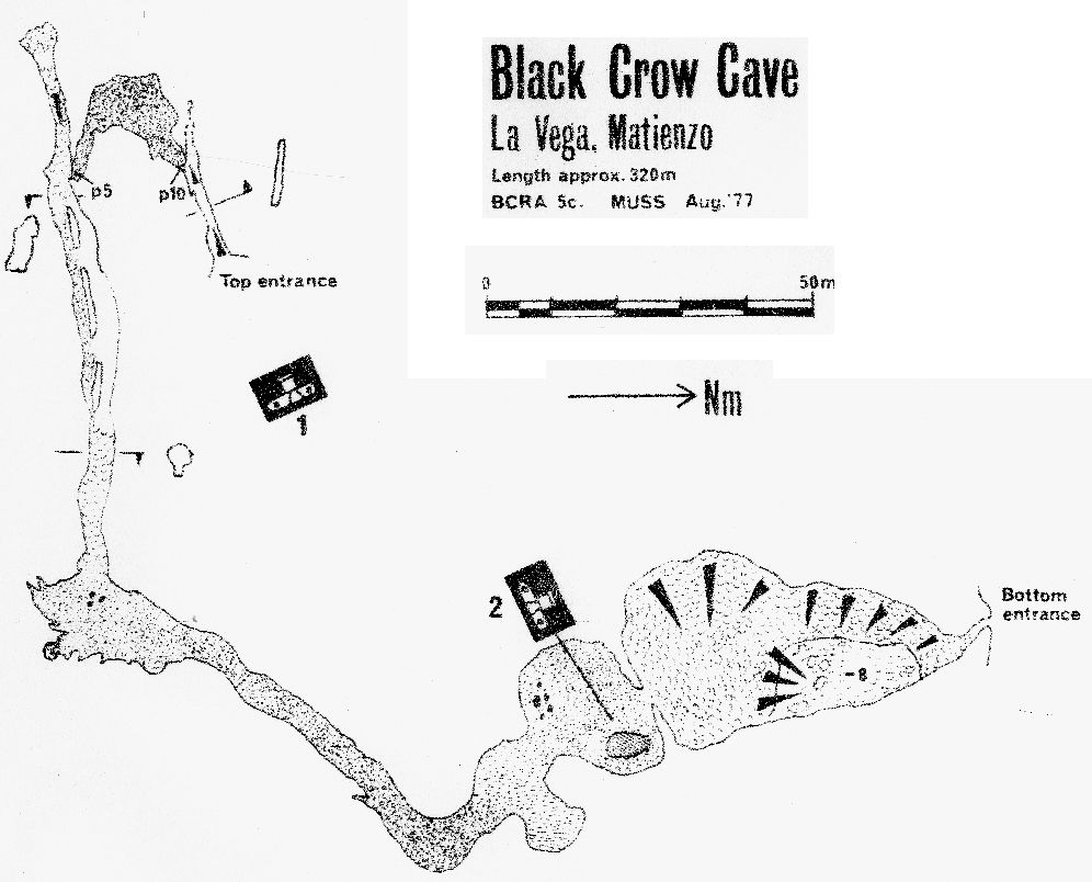
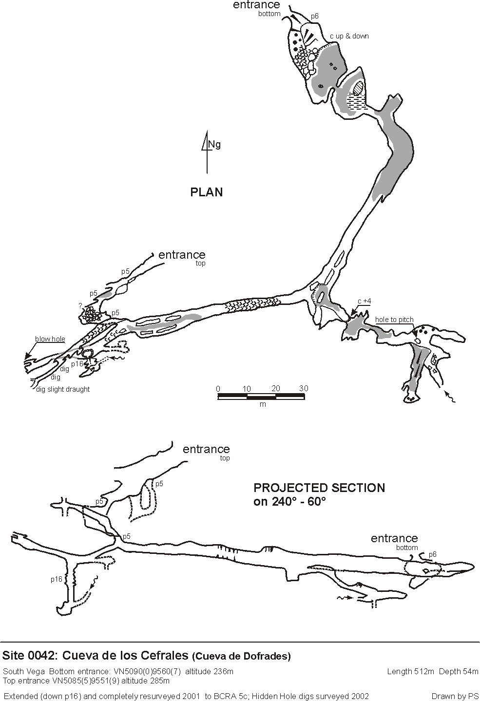
Formally called Cueva de Dofrades (and Black Crow Cave), the correct name only came to light 20 years after its original exploration. In 2008, the entrances were fixed with GPS and the 2001 survey bent around the adjusted centre line. In the summer 2015, the top entrance was identified off Google Earth with the above grid reference. The bottom entrance has been given a separate site number, 4210.
The top entrance is a scalloped, phreatically enlarged rift which slopes
downwards to a 5m pitch-traverse to avoid two pits. A short section of passage
leads to a second pitch/climb into a roomy chamber. (There are possible climbs
to high level passages both in the entrance rift and the chamber.). A squeeze
through at floor level leads to another 5m pitch or handline climb into the
main passage. To the right is a greasy climb to a draughting choke with a
small aven off-set on the left. Digs at the area of the pitches come close
to joining with Hidden Hole, which was extended during
Easter 2002. The digs area was extended during the summers of 2002 and 2003.
Bad air was encountered at the "Hidden Hole connection" in 2002. In 2008,
the whole area was re-explored and extended through a short dig to the west,
as part of the entrance rift. A small draughting hole with a puddle can be
seen at this point.
At the bottom of the pitch, the western passage slopes down to a pit in the
floor, the start of Candy's Pot. First explored at Easter 2001,
this gets very small at the bottom (19m down after a free climb and laddered
section), and has an inlet passage probably coming from the pits that
are traversed around in the entrance. Past Candy's Pot, the passage
slopes up to a calcited choke, with a rift on the right where a blow-hole
can be heard but not reached.
The eastern route at the base of the entrance pitches continues walking-sized
with several levels that unite in a sandy chamber, extensively pocketed.
The way on leads, after 50m to a 15m diameter chamber with a seasonal deep
pool. A squeeze at floor level under an incredibly scalloped wall gives access
to a traverse to the lower entrance (site 4210) that emerges in a grassy valley, just above
the track up to the water tank. This is normally laddered as a 6m pitch
with sloping top.
Two 4m climbs near the bottom entrance were looked at, but both closed in - see 2014 Easter survey
Further explorations in 1991 seemed to reveal, amongst other bits and pieces, a dig through into a well-decorated series of chambers with an inwardly draughting inlet with footprints!
Extensions at Easter 1994 included a hole in the floor, previously chiselled out (by Spaniards?). This pitch choked but a climb to one side enters two small chiselled out crawls which become very small. A wet crawl may dig but was also very small.
Another hole was opened up (location) which enters the surveyed extensions.
A short climb down enters a small dry crawl to the top of a pitch. At the
base is a chamber with two ways out: one leading to larger passage and a
few possible digs, but with no real draught; the second was crawling over
hard sand to a small tube down which is a possible dig with an echo.
No evidence of bats were found in April 2023 during a climb over the top entrance.
References: anon., 1978 (logbook); Corrin J et al, 1978 (survey and photo); Addis F et al, 1979 (survey); Corrin J S and Smith P, 1981; Manchester University Speleological Society, 1982; material in file; Corrin J, 1983a (survey); anon., 1991 (logbook); anon., 1994a (Easter logbook); anon., 1998d (logbook); anon., 2000b (Easter logbook); anon., 2000c (Summer logbook); anon., 2001a (Easter logbook);anon., 2001c (Summer logbook); anon., 2002a (Easter logbook); anon., 2002b (summer logbook); Corrin Juan, 2003a; Corrin Juan, 2003b; anon., 2003c (summer logbook); Corrin Juan, 2005; anon., 2008e (summer logbook); Corrin Juan, 2009; anon., 2014b (Easter logbook); Papard Philip, Corrin Juan and Smith Peter, 2014; anon., 2015c (summer logbook); anon., 2023b (Easter logbook)
Entrance pictures : entrance at Easter 2023 : entrances at Easter 2014
top entrance : closeup of top entrance : bottom entrance
top entrance 1977 or 78 : bottom entrance 1977 or 78
Underground picture(s): Easter 2014 - near bottom entrance
just inside bottom and top entrances : Near bottom entrance, 2008 by Phil Papard
Photos from 2001 and 1977, 1978
Detailed Survey : from 1977: low res high res. : On scanned 1982 South Vega System survey
1:1000 (2001 resurvey + 2002 digs towards Hidden Hole)
from 2008, pdf file (top entrance resurveyed, old survey wrapped around adjusted centre line)
additions to 2008 survey making the 2014 survey
Line Survey :
On area survey :
Survex file : yes (Amended magnetic declination December 2013 to align with Eur79 grid and coordinates altered to fit ETRS89 datum, April 2014.)
Passage direction rose diagram: 30/6/2018